You are here: Home > Network List > TA - USArray Transportable Network (new EarthScope stations) Stations List
> Station W23A Werner Place, Edgewood, NM, USA > Earthquake Result Viewer
W23A Werner Place, Edgewood, NM, USA - Earthquake Result Viewer
| Earthquake location: |
Kuril Islands |
| Earthquake latitude/longitude: |
50.8/155.0 |
| Earthquake time(UTC): |
2009/04/21 (111) 05:26:11 GMT |
| Earthquake Depth: |
152 km |
| Earthquake Magnitude: |
6.0 MB, 6.2 MW, 6.2 MW |
| Earthquake Catalog/Contributor: |
WHDF/NEIC |
|
| Network: |
TA USArray Transportable Network (new EarthScope stations) |
| Station: |
W23A Werner Place, Edgewood, NM, USA |
| Lat/Lon: |
35.16 N/106.15 W |
| Elevation: |
2020 m |
|
| Distance: |
68.7 deg |
| Az: |
60.348 deg |
| Baz: |
317.733 deg |
| Ray Param: |
0.055725735 |
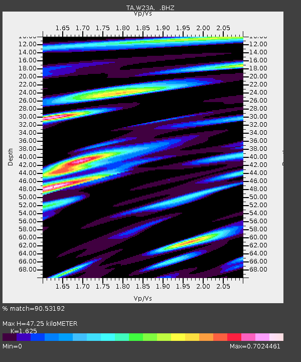
| Estimated Moho Depth: |
47.25 km |
| Estimated Crust Vp/Vs: |
1.62 |
| Assumed Crust Vp: |
6.502 km/s |
| Estimated Crust Vs: |
4.001 km/s |
| Estimated Crust Poisson's Ratio: |
0.20 |
|
| Radial Match: |
90.53192 % |
| Radial Bump: |
400 |
| Transverse Match: |
73.65114 % |
| Transverse Bump: |
400 |
| SOD ConfigId: |
2760 |
| Insert Time: |
2010-03-06 20:25:12.800 +0000 |
| GWidth: |
2.5 |
| Max Bumps: |
400 |
| Tol: |
0.001 |
|
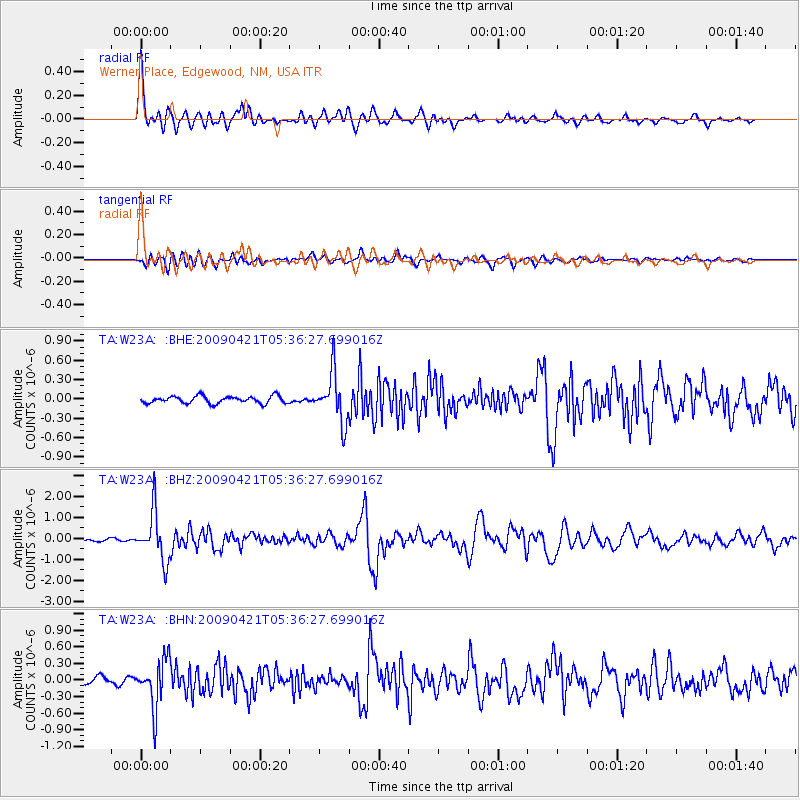
Signal To Noise
| Channel | StoN | STA | LTA |
| TA:W23A: :BHZ:20090421T05:36:27.699016Z | 19.528831 | 1.1636765E-6 | 5.9587617E-8 |
| TA:W23A: :BHN:20090421T05:36:27.699016Z | 7.6223435 | 4.3786557E-7 | 5.7445003E-8 |
| TA:W23A: :BHE:20090421T05:36:27.699016Z | 6.8897295 | 3.8310006E-7 | 5.5604513E-8 |
| Arrivals |
| Ps | 4.7 SECOND |
| PpPs | 18 SECOND |
| PsPs/PpSs | 23 SECOND |


