You are here: Home > Network List > O2 - Oklahoma Consolidated Temporary Seismic Networks Stations List
> Station CHAN Chandler, Oklahoma, USA > Earthquake Result Viewer
CHAN Chandler, Oklahoma, USA - Earthquake Result Viewer
| Earthquake location: |
Central Peru |
| Earthquake latitude/longitude: |
-14.7/-70.1 |
| Earthquake time(UTC): |
2019/03/01 (060) 08:50:41 GMT |
| Earthquake Depth: |
257 km |
| Earthquake Magnitude: |
7.0 mww |
| Earthquake Catalog/Contributor: |
NEIC PDE/us |
|
| Network: |
O2 Oklahoma Consolidated Temporary Seismic Networks |
| Station: |
CHAN Chandler, Oklahoma, USA |
| Lat/Lon: |
35.65 N/96.79 W |
| Elevation: |
266 m |
|
| Distance: |
56.1 deg |
| Az: |
333.871 deg |
| Baz: |
148.445 deg |
| Ray Param: |
0.06348215 |
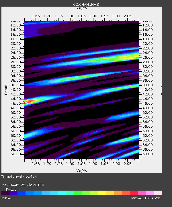
| Estimated Moho Depth: |
45.25 km |
| Estimated Crust Vp/Vs: |
1.60 |
| Assumed Crust Vp: |
6.426 km/s |
| Estimated Crust Vs: |
4.016 km/s |
| Estimated Crust Poisson's Ratio: |
0.18 |
|
| Radial Match: |
87.01424 % |
| Radial Bump: |
400 |
| Transverse Match: |
77.0813 % |
| Transverse Bump: |
400 |
| SOD ConfigId: |
13570011 |
| Insert Time: |
2019-05-02 14:55:25.327 +0000 |
| GWidth: |
2.5 |
| Max Bumps: |
400 |
| Tol: |
0.001 |
|

Signal To Noise
| Channel | StoN | STA | LTA |
| O2:CHAN: :HHZ:20190301T08:59:23.514009Z | 19.003563 | 5.6653344E-6 | 2.981196E-7 |
| O2:CHAN: :HH1:20190301T08:59:23.514009Z | 4.7330694 | 1.6093442E-6 | 3.4002127E-7 |
| O2:CHAN: :HH2:20190301T08:59:23.514009Z | 3.9611418 | 1.259569E-6 | 3.179813E-7 |
| Arrivals |
| Ps | 4.5 SECOND |
| PpPs | 17 SECOND |
| PsPs/PpSs | 22 SECOND |


