You are here: Home > Network List > TA - USArray Transportable Network (new EarthScope stations) Stations List
> Station W23A Werner Place, Edgewood, NM, USA > Earthquake Result Viewer
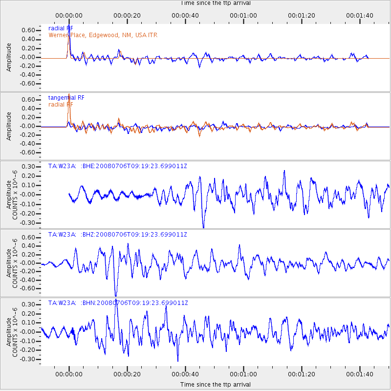
W23A Werner Place, Edgewood, NM, USA - Earthquake Result Viewer
| Earthquake location: |
Kuril Islands |
| Earthquake latitude/longitude: |
45.4/151.0 |
| Earthquake time(UTC): |
2008/07/06 (188) 09:08:20 GMT |
| Earthquake Depth: |
10 km |
| Earthquake Magnitude: |
5.8 MB, 5.4 MS, 5.7 MW, 5.7 MW |
| Earthquake Catalog/Contributor: |
WHDF/NEIC |
|
| Network: |
TA USArray Transportable Network (new EarthScope stations) |
| Station: |
W23A Werner Place, Edgewood, NM, USA |
| Lat/Lon: |
35.16 N/106.15 W |
| Elevation: |
2020 m |
|
| Distance: |
73.9 deg |
| Az: |
56.249 deg |
| Baz: |
314.349 deg |
| Ray Param: |
0.05271999 |
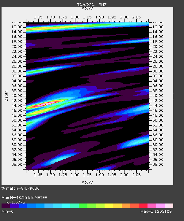
| Estimated Moho Depth: |
43.25 km |
| Estimated Crust Vp/Vs: |
1.68 |
| Assumed Crust Vp: |
6.502 km/s |
| Estimated Crust Vs: |
3.876 km/s |
| Estimated Crust Poisson's Ratio: |
0.22 |
|
| Radial Match: |
84.79636 % |
| Radial Bump: |
400 |
| Transverse Match: |
73.21232 % |
| Transverse Bump: |
400 |
| SOD ConfigId: |
2504 |
| Insert Time: |
2010-03-06 20:25:29.109 +0000 |
| GWidth: |
2.5 |
| Max Bumps: |
400 |
| Tol: |
0.001 |
|
Signal To Noise
| Channel | StoN | STA | LTA |
| TA:W23A: :BHZ:20080706T09:19:23.699011Z | 2.9360414 | 1.5383146E-7 | 5.2394174E-8 |
| TA:W23A: :BHN:20080706T09:19:23.699011Z | 1.0344815 | 5.5317173E-8 | 5.3473336E-8 |
| TA:W23A: :BHE:20080706T09:19:23.699011Z | 1.467459 | 5.7560737E-8 | 3.922477E-8 |
| Arrivals |
| Ps | 4.7 SECOND |
| PpPs | 17 SECOND |
| PsPs/PpSs | 22 SECOND |


