You are here: Home > Network List > TA - USArray Transportable Network (new EarthScope stations) Stations List
> Station T25A Trinidad, CO, USA > Earthquake Result Viewer
T25A Trinidad, CO, USA - Earthquake Result Viewer

| Earthquake location: |
Central Peru |
| Earthquake latitude/longitude: |
-14.7/-70.1 |
| Earthquake time(UTC): |
2019/03/01 (060) 08:50:41 GMT |
| Earthquake Depth: |
257 km |
| Earthquake Magnitude: |
7.0 mww |
| Earthquake Catalog/Contributor: |
NEIC PDE/us |
|
| Network: |
TA USArray Transportable Network (new EarthScope stations) |
| Station: |
T25A Trinidad, CO, USA |
| Lat/Lon: |
37.14 N/104.41 W |
| Elevation: |
2017 m |
|
| Distance: |
60.8 deg |
| Az: |
328.964 deg |
| Baz: |
141.364 deg |
| Ray Param: |
0.060441207 |
| Estimated Moho Depth: |
28.5 km |
| Estimated Crust Vp/Vs: |
1.75 |
| Assumed Crust Vp: |
6.316 km/s |
| Estimated Crust Vs: |
3.599 km/s |
| Estimated Crust Poisson's Ratio: |
0.26 |
|
| Radial Match: |
91.90401 % |
| Radial Bump: |
331 |
| Transverse Match: |
83.69418 % |
| Transverse Bump: |
387 |
| SOD ConfigId: |
13570011 |
| Insert Time: |
2019-05-02 14:58:35.897 +0000 |
| GWidth: |
2.5 |
| Max Bumps: |
400 |
| Tol: |
0.001 |
|
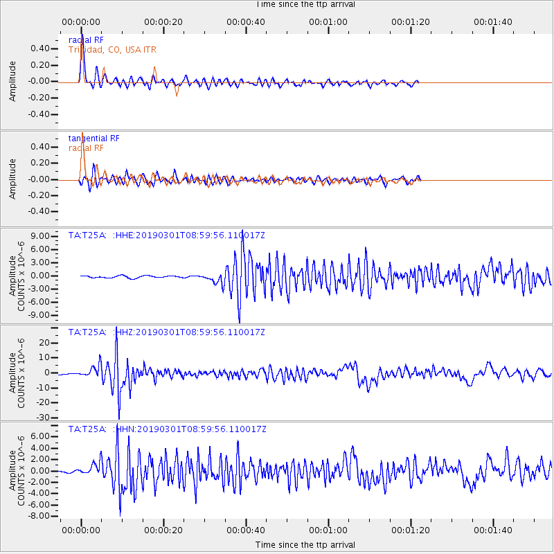
Signal To Noise
| Channel | StoN | STA | LTA |
| TA:T25A: :HHZ:20190301T08:59:56.110017Z | 24.097908 | 4.0433843E-6 | 1.6778984E-7 |
| TA:T25A: :HHN:20190301T08:59:56.110017Z | 7.2046275 | 1.069543E-6 | 1.4845223E-7 |
| TA:T25A: :HHE:20190301T08:59:56.110017Z | 4.6046667 | 1.121769E-6 | 2.4361566E-7 |
| Arrivals |
| Ps | 3.6 SECOND |
| PpPs | 12 SECOND |
| PsPs/PpSs | 15 SECOND |


