You are here: Home > Network List > US - United States National Seismic Network Stations List
> Station RLMT Red Lodge, Montana, USA > Earthquake Result Viewer
RLMT Red Lodge, Montana, USA - Earthquake Result Viewer
| Earthquake location: |
Central Peru |
| Earthquake latitude/longitude: |
-14.7/-70.1 |
| Earthquake time(UTC): |
2019/03/01 (060) 08:50:41 GMT |
| Earthquake Depth: |
257 km |
| Earthquake Magnitude: |
7.0 mww |
| Earthquake Catalog/Contributor: |
NEIC PDE/us |
|
| Network: |
US United States National Seismic Network |
| Station: |
RLMT Red Lodge, Montana, USA |
| Lat/Lon: |
45.12 N/109.27 W |
| Elevation: |
2086 m |
|
| Distance: |
69.3 deg |
| Az: |
331.462 deg |
| Baz: |
139.229 deg |
| Ray Param: |
0.054979898 |
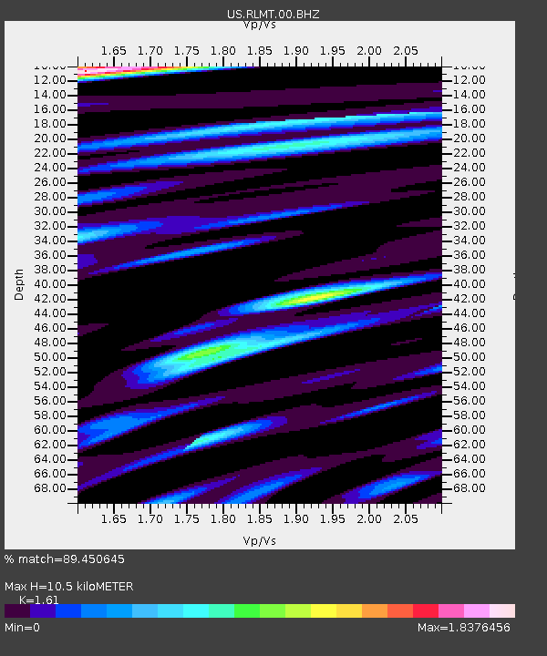
| Estimated Moho Depth: |
10.5 km |
| Estimated Crust Vp/Vs: |
1.61 |
| Assumed Crust Vp: |
6.242 km/s |
| Estimated Crust Vs: |
3.877 km/s |
| Estimated Crust Poisson's Ratio: |
0.19 |
|
| Radial Match: |
89.450645 % |
| Radial Bump: |
400 |
| Transverse Match: |
98.786446 % |
| Transverse Bump: |
223 |
| SOD ConfigId: |
13570011 |
| Insert Time: |
2019-05-02 14:59:16.909 +0000 |
| GWidth: |
2.5 |
| Max Bumps: |
400 |
| Tol: |
0.001 |
|

Signal To Noise
| Channel | StoN | STA | LTA |
| US:RLMT:00:BHZ:20190301T09:00:50.298982Z | 19.73065 | 2.7463607E-6 | 1.3919261E-7 |
| US:RLMT:00:BH1:20190301T09:00:50.298982Z | 6.7125187 | 1.2173272E-6 | 1.8135177E-7 |
| US:RLMT:00:BH2:20190301T09:00:50.298982Z | 10.401274 | 2.1725102E-6 | 2.0886962E-7 |
| Arrivals |
| Ps | 1.1 SECOND |
| PpPs | 4.2 SECOND |
| PsPs/PpSs | 5.3 SECOND |


