You are here: Home > Network List > AV - Alaska Volcano Observatory Stations List
> Station MAPS Pakushin Southeast, Makushin Volcano, Alaska > Earthquake Result Viewer
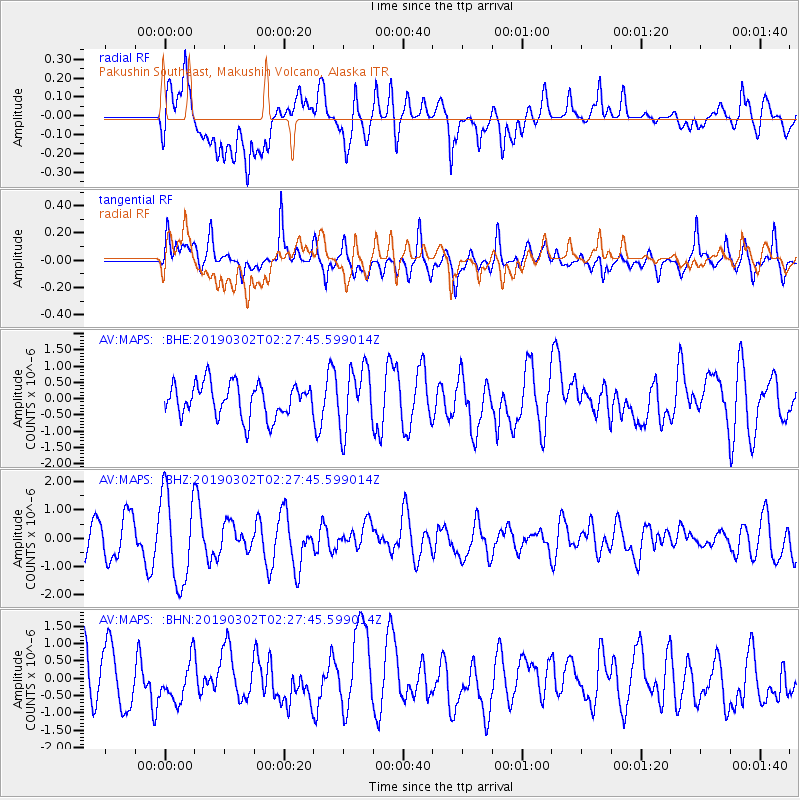
MAPS Pakushin Southeast, Makushin Volcano, Alaska - Earthquake Result Viewer
*The percent match for this event was below the threshold and hence no stack was calculated.
| Earthquake location: |
Solomon Islands |
| Earthquake latitude/longitude: |
-7.0/155.8 |
| Earthquake time(UTC): |
2019/03/02 (061) 02:17:23 GMT |
| Earthquake Depth: |
69 km |
| Earthquake Magnitude: |
5.2 Mww |
| Earthquake Catalog/Contributor: |
NEIC PDE/us |
|
| Network: |
AV Alaska Volcano Observatory |
| Station: |
MAPS Pakushin Southeast, Makushin Volcano, Alaska |
| Lat/Lon: |
53.81 N/166.94 W |
| Elevation: |
333 m |
|
| Distance: |
68.2 deg |
| Az: |
22.767 deg |
| Baz: |
220.369 deg |
| Ray Param: |
$rayparam |
*The percent match for this event was below the threshold and hence was not used in the summary stack. |
|
| Radial Match: |
66.57301 % |
| Radial Bump: |
400 |
| Transverse Match: |
59.2272 % |
| Transverse Bump: |
400 |
| SOD ConfigId: |
13570011 |
| Insert Time: |
2019-05-02 15:02:04.030 +0000 |
| GWidth: |
2.5 |
| Max Bumps: |
400 |
| Tol: |
0.001 |
|
Signal To Noise
| Channel | StoN | STA | LTA |
| AV:MAPS: :BHZ:20190302T02:27:45.599014Z | 2.5133705 | 1.6087314E-6 | 6.4006935E-7 |
| AV:MAPS: :BHN:20190302T02:27:45.599014Z | 0.7444927 | 5.9459956E-7 | 7.98664E-7 |
| AV:MAPS: :BHE:20190302T02:27:45.599014Z | 1.8674538 | 9.626455E-7 | 5.1548557E-7 |
| Arrivals |
| Ps | |
| PpPs | |
| PsPs/PpSs | |


