You are here: Home > Network List > TA - USArray Transportable Network (new EarthScope stations) Stations List
> Station W23A Werner Place, Edgewood, NM, USA > Earthquake Result Viewer
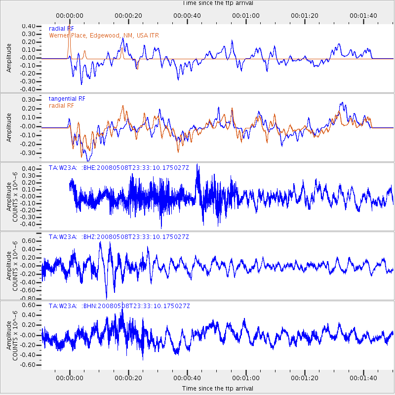
W23A Werner Place, Edgewood, NM, USA - Earthquake Result Viewer
*The percent match for this event was below the threshold and hence no stack was calculated.
| Earthquake location: |
Near East Coast Of Honshu, Japan |
| Earthquake latitude/longitude: |
36.1/141.7 |
| Earthquake time(UTC): |
2008/05/08 (129) 23:21:06 GMT |
| Earthquake Depth: |
17 km |
| Earthquake Magnitude: |
5.6 MB, 5.2 MS, 5.6 MW, 5.5 MW |
| Earthquake Catalog/Contributor: |
WHDF/NEIC |
|
| Network: |
TA USArray Transportable Network (new EarthScope stations) |
| Station: |
W23A Werner Place, Edgewood, NM, USA |
| Lat/Lon: |
35.16 N/106.15 W |
| Elevation: |
2020 m |
|
| Distance: |
85.1 deg |
| Az: |
49.607 deg |
| Baz: |
311.173 deg |
| Ray Param: |
$rayparam |
*The percent match for this event was below the threshold and hence was not used in the summary stack. |
|
| Radial Match: |
33.13623 % |
| Radial Bump: |
400 |
| Transverse Match: |
33.170704 % |
| Transverse Bump: |
400 |
| SOD ConfigId: |
2504 |
| Insert Time: |
2010-03-06 20:26:50.972 +0000 |
| GWidth: |
2.5 |
| Max Bumps: |
400 |
| Tol: |
0.001 |
|
Signal To Noise
| Channel | StoN | STA | LTA |
| TA:W23A: :BHZ:20080508T23:33:10.175027Z | 2.0882666 | 1.8664893E-7 | 8.937984E-8 |
| TA:W23A: :BHN:20080508T23:33:10.175027Z | 0.43538544 | 1.07952374E-7 | 2.4794667E-7 |
| TA:W23A: :BHE:20080508T23:33:10.175027Z | 1.2701453 | 1.3065669E-7 | 1.0286751E-7 |
| Arrivals |
| Ps | |
| PpPs | |
| PsPs/PpSs | |


