You are here: Home > Network List > TA - USArray Transportable Network (new EarthScope stations) Stations List
> Station G12A Big Creek, Yellow Pine, ID, USA > Earthquake Result Viewer
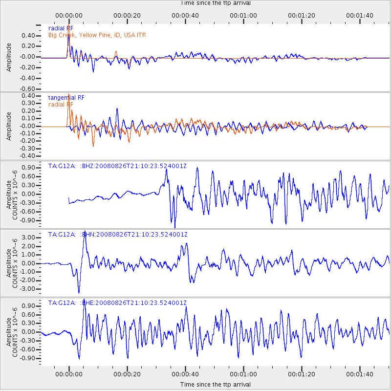
G12A Big Creek, Yellow Pine, ID, USA - Earthquake Result Viewer
| Earthquake location: |
Peru-Brazil Border Region |
| Earthquake latitude/longitude: |
-7.6/-74.4 |
| Earthquake time(UTC): |
2008/08/26 (239) 21:00:36 GMT |
| Earthquake Depth: |
154 km |
| Earthquake Magnitude: |
6.0 MB, 6.4 MW, 6.4 MW |
| Earthquake Catalog/Contributor: |
WHDF/NEIC |
|
| Network: |
TA USArray Transportable Network (new EarthScope stations) |
| Station: |
G12A Big Creek, Yellow Pine, ID, USA |
| Lat/Lon: |
45.13 N/115.33 W |
| Elevation: |
1780 m |
|
| Distance: |
64.1 deg |
| Az: |
328.955 deg |
| Baz: |
133.769 deg |
| Ray Param: |
0.058695976 |
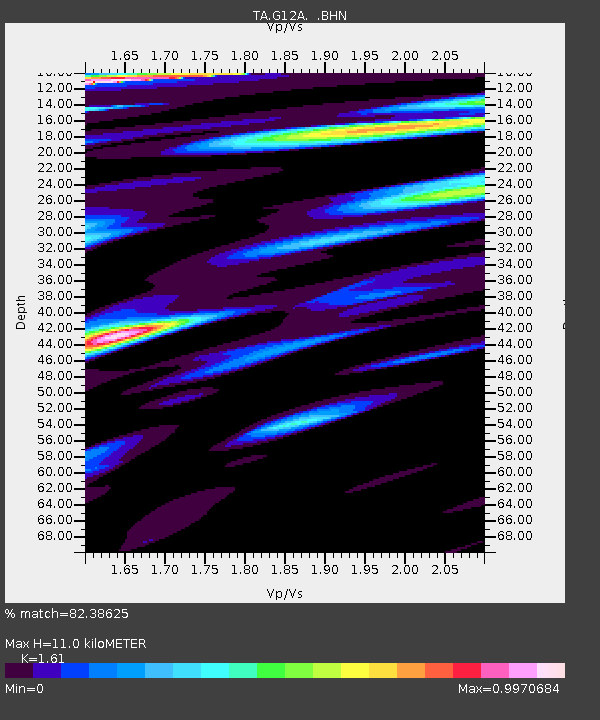
| Estimated Moho Depth: |
11.0 km |
| Estimated Crust Vp/Vs: |
1.61 |
| Assumed Crust Vp: |
6.577 km/s |
| Estimated Crust Vs: |
4.085 km/s |
| Estimated Crust Poisson's Ratio: |
0.19 |
|
| Radial Match: |
82.38625 % |
| Radial Bump: |
400 |
| Transverse Match: |
71.27824 % |
| Transverse Bump: |
400 |
| SOD ConfigId: |
2504 |
| Insert Time: |
2010-03-06 20:27:30.714 +0000 |
| GWidth: |
2.5 |
| Max Bumps: |
400 |
| Tol: |
0.001 |
|
Signal To Noise
| Channel | StoN | STA | LTA |
| TA:G12A: :BHN:20080826T21:10:23.524001Z | 26.717545 | 1.3374528E-6 | 5.005897E-8 |
| TA:G12A: :BHE:20080826T21:10:23.524001Z | 6.8568664 | 3.7718064E-7 | 5.5007728E-8 |
| TA:G12A: :BHZ:20080826T21:10:23.524001Z | 3.8609643 | 4.2831437E-7 | 1.1093456E-7 |
| Arrivals |
| Ps | 1.1 SECOND |
| PpPs | 4.2 SECOND |
| PsPs/PpSs | 5.2 SECOND |


