You are here: Home > Network List > IU - Global Seismograph Network (GSN - IRIS/USGS) Stations List
> Station FURI Mt. Furi, Ethiopia > Earthquake Result Viewer
FURI Mt. Furi, Ethiopia - Earthquake Result Viewer
*The percent match for this event was below the threshold and hence no stack was calculated.
| Earthquake location: |
Romania |
| Earthquake latitude/longitude: |
45.7/26.6 |
| Earthquake time(UTC): |
2016/09/23 (267) 23:11:20 GMT |
| Earthquake Depth: |
88 km |
| Earthquake Magnitude: |
5.6 MO |
| Earthquake Catalog/Contributor: |
NEIC PDE/NEIC ALERT |
|
| Network: |
IU Global Seismograph Network (GSN - IRIS/USGS) |
| Station: |
FURI Mt. Furi, Ethiopia |
| Lat/Lon: |
8.90 N/38.68 E |
| Elevation: |
2570 m |
|
| Distance: |
38.1 deg |
| Az: |
160.479 deg |
| Baz: |
346.297 deg |
| Ray Param: |
$rayparam |
*The percent match for this event was below the threshold and hence was not used in the summary stack. |
|
| Radial Match: |
74.69597 % |
| Radial Bump: |
400 |
| Transverse Match: |
58.08337 % |
| Transverse Bump: |
400 |
| SOD ConfigId: |
1634031 |
| Insert Time: |
2016-10-07 23:14:33.598 +0000 |
| GWidth: |
2.5 |
| Max Bumps: |
400 |
| Tol: |
0.001 |
|
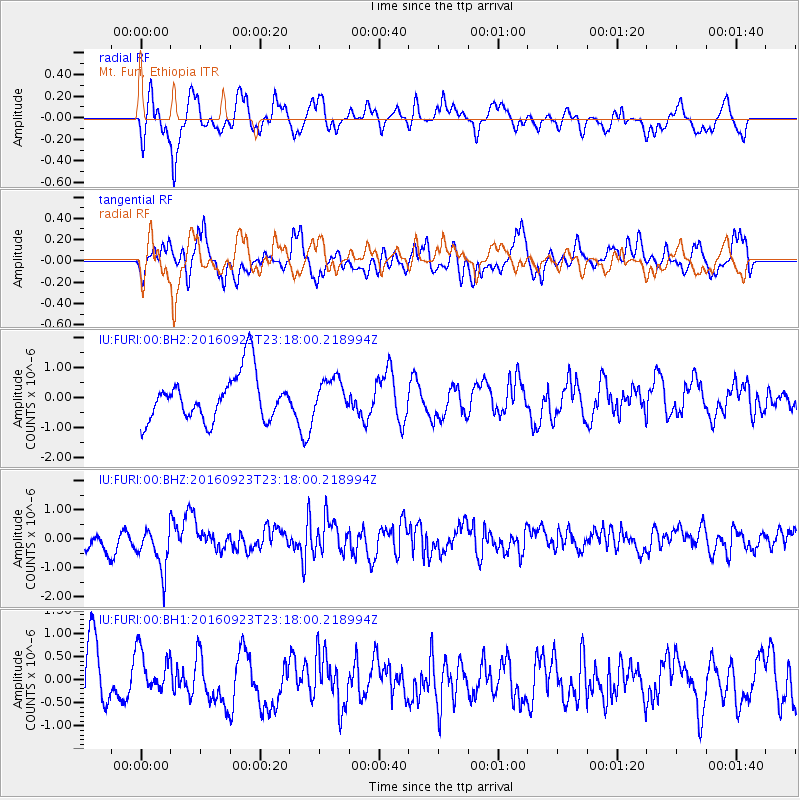
Signal To Noise
| Channel | StoN | STA | LTA |
| IU:FURI:00:BHZ:20160923T23:18:00.218994Z | 1.5393769 | 7.4997075E-7 | 4.8719113E-7 |
| IU:FURI:00:BH1:20160923T23:18:00.218994Z | 0.6568106 | 4.6839384E-7 | 7.131338E-7 |
| IU:FURI:00:BH2:20160923T23:18:00.218994Z | 0.70487916 | 5.43736E-7 | 7.71389E-7 |
| Arrivals |
| Ps | |
| PpPs | |
| PsPs/PpSs | |


