You are here: Home > Network List > TA - USArray Transportable Network (new EarthScope stations) Stations List
> Station G12A Big Creek, Yellow Pine, ID, USA > Earthquake Result Viewer
G12A Big Creek, Yellow Pine, ID, USA - Earthquake Result Viewer
| Earthquake location: |
Kermadec Islands Region |
| Earthquake latitude/longitude: |
-27.4/-176.3 |
| Earthquake time(UTC): |
2009/02/18 (049) 21:53:45 GMT |
| Earthquake Depth: |
25 km |
| Earthquake Magnitude: |
6.8 MB, 7.2 MS, 6.9 MW, 6.9 MW |
| Earthquake Catalog/Contributor: |
WHDF/NEIC |
|
| Network: |
TA USArray Transportable Network (new EarthScope stations) |
| Station: |
G12A Big Creek, Yellow Pine, ID, USA |
| Lat/Lon: |
45.13 N/115.33 W |
| Elevation: |
1780 m |
|
| Distance: |
91.1 deg |
| Az: |
38.263 deg |
| Baz: |
231.041 deg |
| Ray Param: |
0.0416262 |
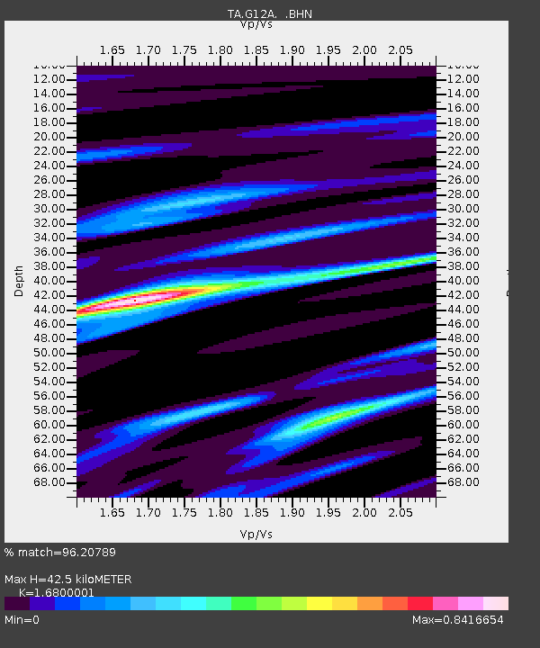
| Estimated Moho Depth: |
42.5 km |
| Estimated Crust Vp/Vs: |
1.68 |
| Assumed Crust Vp: |
6.577 km/s |
| Estimated Crust Vs: |
3.915 km/s |
| Estimated Crust Poisson's Ratio: |
0.23 |
|
| Radial Match: |
96.20789 % |
| Radial Bump: |
284 |
| Transverse Match: |
91.32168 % |
| Transverse Bump: |
369 |
| SOD ConfigId: |
2658 |
| Insert Time: |
2010-03-06 20:27:45.407 +0000 |
| GWidth: |
2.5 |
| Max Bumps: |
400 |
| Tol: |
0.001 |
|

Signal To Noise
| Channel | StoN | STA | LTA |
| TA:G12A: :BHN:20090218T22:06:15.875027Z | 10.478684 | 1.3737211E-6 | 1.3109671E-7 |
| TA:G12A: :BHE:20090218T22:06:15.875027Z | 1.8047564 | 1.8701127E-7 | 1.0362133E-7 |
| TA:G12A: :BHZ:20090218T22:06:15.875027Z | 5.744477 | 3.076972E-7 | 5.356401E-8 |
| Arrivals |
| Ps | 4.5 SECOND |
| PpPs | 17 SECOND |
| PsPs/PpSs | 21 SECOND |


