You are here: Home > Network List > TA - USArray Transportable Network (new EarthScope stations) Stations List
> Station G12A Big Creek, Yellow Pine, ID, USA > Earthquake Result Viewer
G12A Big Creek, Yellow Pine, ID, USA - Earthquake Result Viewer
| Earthquake location: |
Andreanof Islands, Aleutian Is. |
| Earthquake latitude/longitude: |
51.9/-179.2 |
| Earthquake time(UTC): |
2008/04/16 (107) 05:54:19 GMT |
| Earthquake Depth: |
13 km |
| Earthquake Magnitude: |
6.1 MB, 6.5 MS, 6.6 MW, 6.6 MW |
| Earthquake Catalog/Contributor: |
WHDF/NEIC |
|
| Network: |
TA USArray Transportable Network (new EarthScope stations) |
| Station: |
G12A Big Creek, Yellow Pine, ID, USA |
| Lat/Lon: |
45.13 N/115.33 W |
| Elevation: |
1780 m |
|
| Distance: |
41.6 deg |
| Az: |
73.108 deg |
| Baz: |
303.079 deg |
| Ray Param: |
0.073677085 |
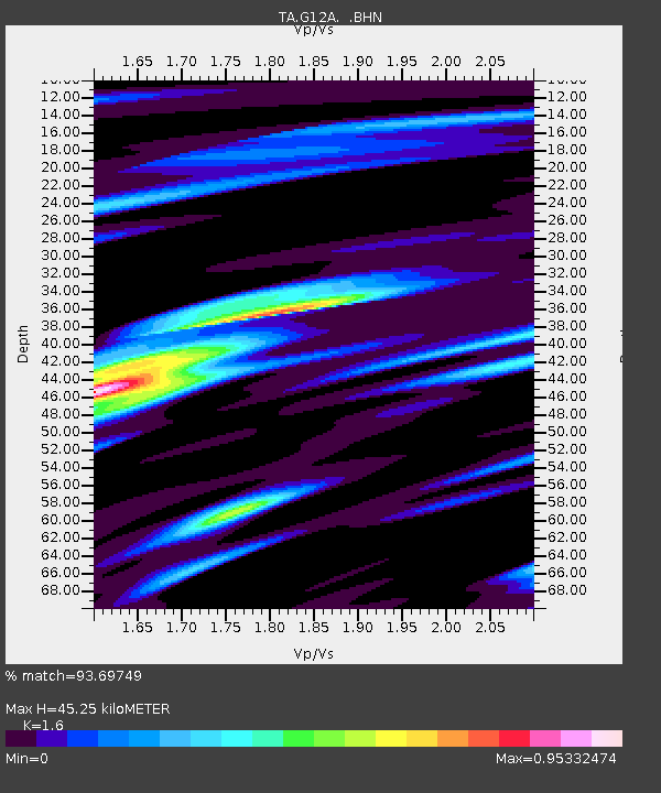
| Estimated Moho Depth: |
45.25 km |
| Estimated Crust Vp/Vs: |
1.60 |
| Assumed Crust Vp: |
6.577 km/s |
| Estimated Crust Vs: |
4.111 km/s |
| Estimated Crust Poisson's Ratio: |
0.18 |
|
| Radial Match: |
93.69749 % |
| Radial Bump: |
400 |
| Transverse Match: |
84.02111 % |
| Transverse Bump: |
400 |
| SOD ConfigId: |
2504 |
| Insert Time: |
2010-03-06 20:28:14.276 +0000 |
| GWidth: |
2.5 |
| Max Bumps: |
400 |
| Tol: |
0.001 |
|
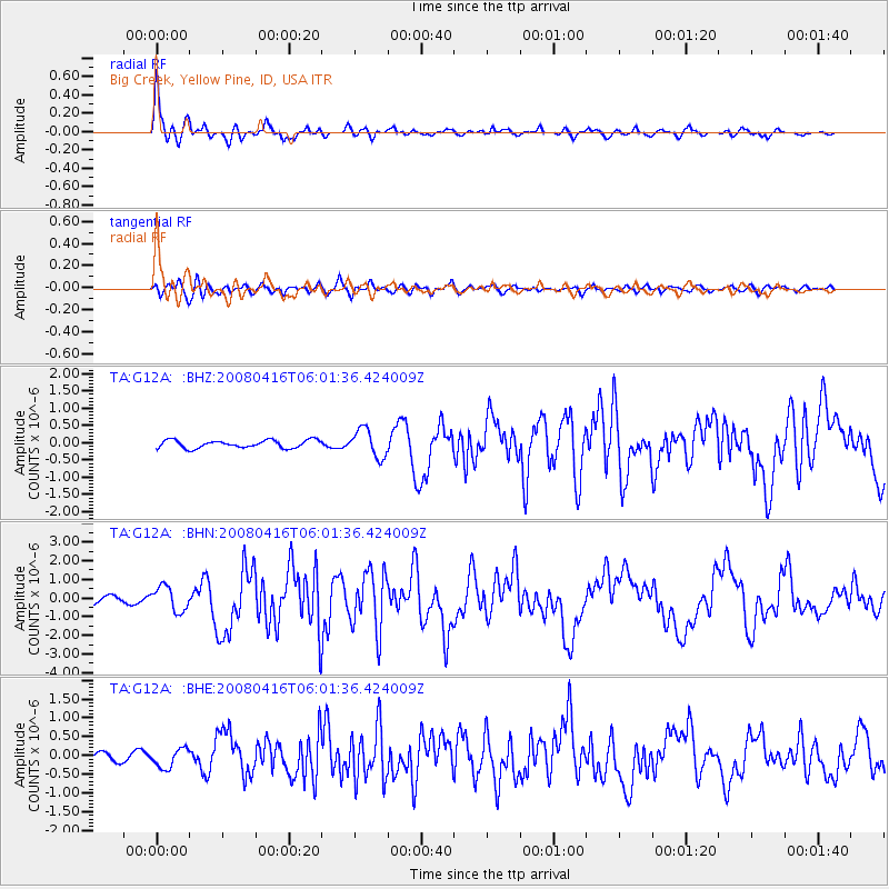
Signal To Noise
| Channel | StoN | STA | LTA |
| TA:G12A: :BHN:20080416T06:01:36.424009Z | 4.7134376 | 6.6317125E-7 | 1.40698E-7 |
| TA:G12A: :BHE:20080416T06:01:36.424009Z | 2.9358194 | 2.5819926E-7 | 8.7947946E-8 |
| TA:G12A: :BHZ:20080416T06:01:36.424009Z | 3.614583 | 4.0702258E-7 | 1.1260568E-7 |
| Arrivals |
| Ps | 4.5 SECOND |
| PpPs | 17 SECOND |
| PsPs/PpSs | 21 SECOND |


