You are here: Home > Network List > KO - Kandilli Observatory Digital Broadband Seismic Network Stations List
> Station GURO KO.GURO > Earthquake Result Viewer
GURO KO.GURO - Earthquake Result Viewer
| Earthquake location: |
Off Coast Of Hokkaido, Japan |
| Earthquake latitude/longitude: |
41.9/146.9 |
| Earthquake time(UTC): |
2019/03/02 (061) 03:22:52 GMT |
| Earthquake Depth: |
10 km |
| Earthquake Magnitude: |
6.0 Mww |
| Earthquake Catalog/Contributor: |
NEIC PDE/us |
|
| Network: |
KO Kandilli Observatory Digital Broadband Seismic Network |
| Station: |
GURO KO.GURO |
| Lat/Lon: |
38.55 N/42.03 E |
| Elevation: |
1388 m |
|
| Distance: |
74.8 deg |
| Az: |
308.258 deg |
| Baz: |
48.351 deg |
| Ray Param: |
0.05210753 |
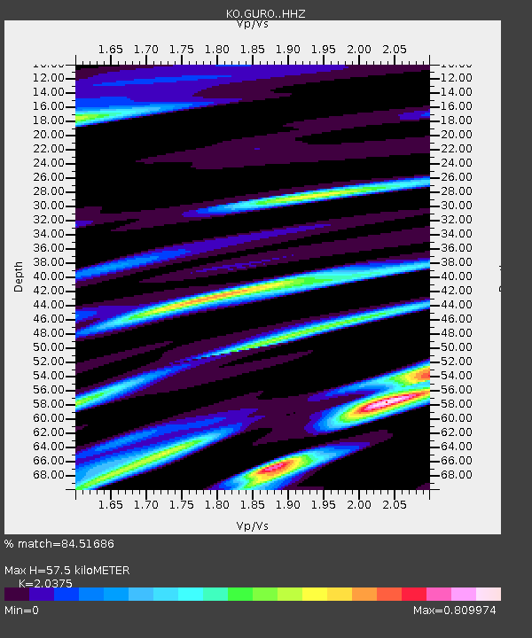
| Estimated Moho Depth: |
57.5 km |
| Estimated Crust Vp/Vs: |
2.04 |
| Assumed Crust Vp: |
6.35 km/s |
| Estimated Crust Vs: |
3.117 km/s |
| Estimated Crust Poisson's Ratio: |
0.34 |
|
| Radial Match: |
84.51686 % |
| Radial Bump: |
379 |
| Transverse Match: |
79.80118 % |
| Transverse Bump: |
400 |
| SOD ConfigId: |
13570011 |
| Insert Time: |
2019-05-02 15:13:08.657 +0000 |
| GWidth: |
2.5 |
| Max Bumps: |
400 |
| Tol: |
0.001 |
|

Signal To Noise
| Channel | StoN | STA | LTA |
| KO:GURO: :HHZ:20190302T03:34:01.310022Z | 5.624232 | 3.6700342E-7 | 6.5253964E-8 |
| KO:GURO: :HHN:20190302T03:34:01.310022Z | 4.545914 | 2.4625342E-7 | 5.417028E-8 |
| KO:GURO: :HHE:20190302T03:34:01.310022Z | 1.1056013 | 6.284854E-8 | 5.684558E-8 |
| Arrivals |
| Ps | 9.7 SECOND |
| PpPs | 27 SECOND |
| PsPs/PpSs | 36 SECOND |


