You are here: Home > Network List > TA - USArray Transportable Network (new EarthScope stations) Stations List
> Station G12A Big Creek, Yellow Pine, ID, USA > Earthquake Result Viewer
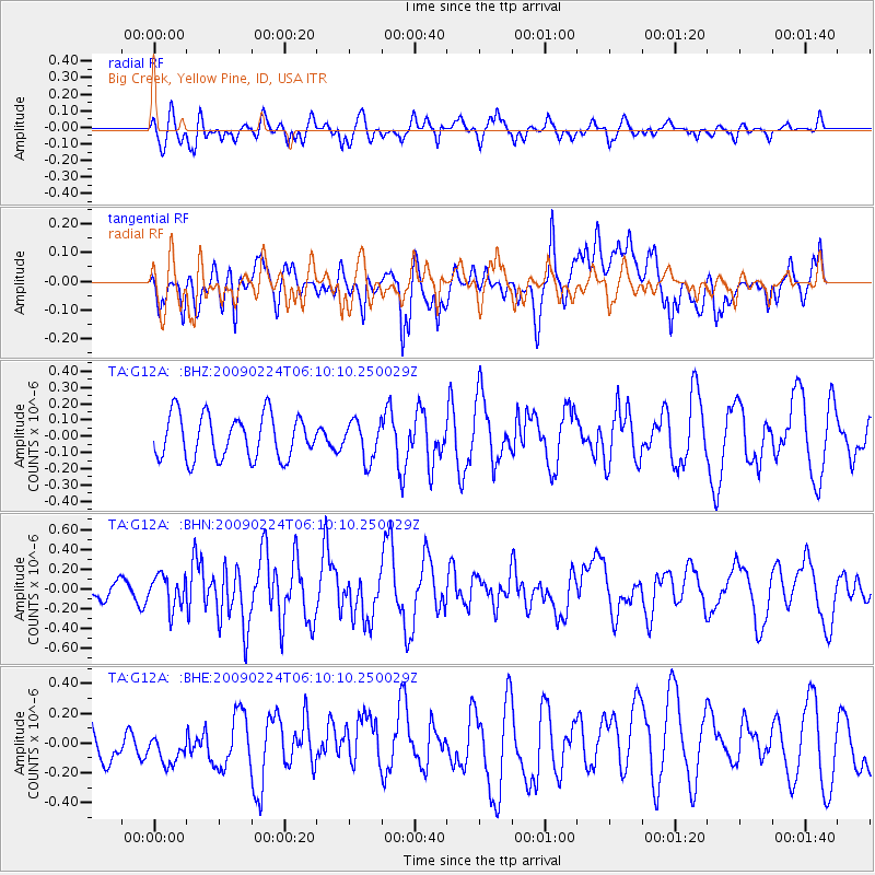
G12A Big Creek, Yellow Pine, ID, USA - Earthquake Result Viewer
*The percent match for this event was below the threshold and hence no stack was calculated.
| Earthquake location: |
South Of Mariana Islands |
| Earthquake latitude/longitude: |
13.8/146.3 |
| Earthquake time(UTC): |
2009/02/24 (055) 05:57:59 GMT |
| Earthquake Depth: |
5.0 km |
| Earthquake Magnitude: |
5.7 MB, 5.7 MS, 5.9 MW, 5.8 MW |
| Earthquake Catalog/Contributor: |
WHDF/NEIC |
|
| Network: |
TA USArray Transportable Network (new EarthScope stations) |
| Station: |
G12A Big Creek, Yellow Pine, ID, USA |
| Lat/Lon: |
45.13 N/115.33 W |
| Elevation: |
1780 m |
|
| Distance: |
86.1 deg |
| Az: |
44.583 deg |
| Baz: |
285.551 deg |
| Ray Param: |
$rayparam |
*The percent match for this event was below the threshold and hence was not used in the summary stack. |
|
| Radial Match: |
58.382637 % |
| Radial Bump: |
400 |
| Transverse Match: |
67.49315 % |
| Transverse Bump: |
400 |
| SOD ConfigId: |
2658 |
| Insert Time: |
2010-03-06 20:29:03.226 +0000 |
| GWidth: |
2.5 |
| Max Bumps: |
400 |
| Tol: |
0.001 |
|
Signal To Noise
| Channel | StoN | STA | LTA |
| TA:G12A: :BHN:20090224T06:10:10.250029Z | 0.8003105 | 1.6190072E-7 | 2.0229737E-7 |
| TA:G12A: :BHE:20090224T06:10:10.250029Z | 1.2668308 | 1.3606771E-7 | 1.0740795E-7 |
| TA:G12A: :BHZ:20090224T06:10:10.250029Z | 0.8863359 | 1.184396E-7 | 1.3362835E-7 |
| Arrivals |
| Ps | |
| PpPs | |
| PsPs/PpSs | |


