You are here: Home > Network List > TA - USArray Transportable Network (new EarthScope stations) Stations List
> Station G12A Big Creek, Yellow Pine, ID, USA > Earthquake Result Viewer
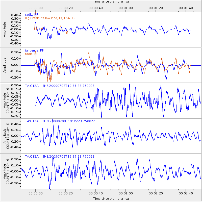
G12A Big Creek, Yellow Pine, ID, USA - Earthquake Result Viewer
*The percent match for this event was below the threshold and hence no stack was calculated.
| Earthquake location: |
Southeast Of Easter Island |
| Earthquake latitude/longitude: |
-36.0/-102.7 |
| Earthquake time(UTC): |
2009/07/08 (189) 19:23:37 GMT |
| Earthquake Depth: |
12 km |
| Earthquake Magnitude: |
5.5 MS, 5.4 MB, 6.0 MW, 5.9 MW |
| Earthquake Catalog/Contributor: |
WHDF/NEIC |
|
| Network: |
TA USArray Transportable Network (new EarthScope stations) |
| Station: |
G12A Big Creek, Yellow Pine, ID, USA |
| Lat/Lon: |
45.13 N/115.33 W |
| Elevation: |
1780 m |
|
| Distance: |
81.6 deg |
| Az: |
350.991 deg |
| Baz: |
169.667 deg |
| Ray Param: |
$rayparam |
*The percent match for this event was below the threshold and hence was not used in the summary stack. |
|
| Radial Match: |
65.4296 % |
| Radial Bump: |
400 |
| Transverse Match: |
59.47693 % |
| Transverse Bump: |
400 |
| SOD ConfigId: |
2648 |
| Insert Time: |
2010-03-06 20:29:27.423 +0000 |
| GWidth: |
2.5 |
| Max Bumps: |
400 |
| Tol: |
0.001 |
|
Signal To Noise
| Channel | StoN | STA | LTA |
| TA:G12A: :BHN:20090708T19:35:23.75002Z | 1.9165754 | 1.0403365E-7 | 5.4281013E-8 |
| TA:G12A: :BHE:20090708T19:35:23.75002Z | 0.9715945 | 5.583178E-8 | 5.7464074E-8 |
| TA:G12A: :BHZ:20090708T19:35:23.75002Z | 1.2501851 | 4.818975E-8 | 3.8546094E-8 |
| Arrivals |
| Ps | |
| PpPs | |
| PsPs/PpSs | |


