You are here: Home > Network List > TA - USArray Transportable Network (new EarthScope stations) Stations List
> Station D20K Etivluk River, AK, USA > Earthquake Result Viewer
D20K Etivluk River, AK, USA - Earthquake Result Viewer
| Earthquake location: |
Off Coast Of Hokkaido, Japan |
| Earthquake latitude/longitude: |
41.9/146.9 |
| Earthquake time(UTC): |
2019/03/02 (061) 03:22:52 GMT |
| Earthquake Depth: |
10 km |
| Earthquake Magnitude: |
6.0 Mww |
| Earthquake Catalog/Contributor: |
NEIC PDE/us |
|
| Network: |
TA USArray Transportable Network (new EarthScope stations) |
| Station: |
D20K Etivluk River, AK, USA |
| Lat/Lon: |
68.71 N/156.61 W |
| Elevation: |
577 m |
|
| Distance: |
39.6 deg |
| Az: |
28.509 deg |
| Baz: |
257.232 deg |
| Ray Param: |
0.074886434 |
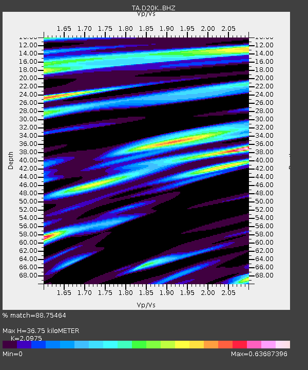
| Estimated Moho Depth: |
36.75 km |
| Estimated Crust Vp/Vs: |
2.10 |
| Assumed Crust Vp: |
6.221 km/s |
| Estimated Crust Vs: |
2.966 km/s |
| Estimated Crust Poisson's Ratio: |
0.35 |
|
| Radial Match: |
88.75464 % |
| Radial Bump: |
400 |
| Transverse Match: |
89.402985 % |
| Transverse Bump: |
400 |
| SOD ConfigId: |
13570011 |
| Insert Time: |
2019-05-02 15:18:27.528 +0000 |
| GWidth: |
2.5 |
| Max Bumps: |
400 |
| Tol: |
0.001 |
|

Signal To Noise
| Channel | StoN | STA | LTA |
| TA:D20K: :BHZ:20190302T03:29:53.300012Z | 12.249073 | 2.1666988E-6 | 1.7688676E-7 |
| TA:D20K: :BHN:20190302T03:29:53.300012Z | 2.016831 | 3.157513E-7 | 1.5655814E-7 |
| TA:D20K: :BHE:20190302T03:29:53.300012Z | 3.6361945 | 7.823214E-7 | 2.151484E-7 |
| Arrivals |
| Ps | 6.9 SECOND |
| PpPs | 17 SECOND |
| PsPs/PpSs | 24 SECOND |


