You are here: Home > Network List > TA - USArray Transportable Network (new EarthScope stations) Stations List
> Station D28M Stokes Point, YT, CAN > Earthquake Result Viewer
D28M Stokes Point, YT, CAN - Earthquake Result Viewer
| Earthquake location: |
Off Coast Of Hokkaido, Japan |
| Earthquake latitude/longitude: |
41.9/146.9 |
| Earthquake time(UTC): |
2019/03/02 (061) 03:22:52 GMT |
| Earthquake Depth: |
10 km |
| Earthquake Magnitude: |
6.0 Mww |
| Earthquake Catalog/Contributor: |
NEIC PDE/us |
|
| Network: |
TA USArray Transportable Network (new EarthScope stations) |
| Station: |
D28M Stokes Point, YT, CAN |
| Lat/Lon: |
69.33 N/138.74 W |
| Elevation: |
32 m |
|
| Distance: |
46.1 deg |
| Az: |
28.349 deg |
| Baz: |
273.81 deg |
| Ray Param: |
0.07088427 |
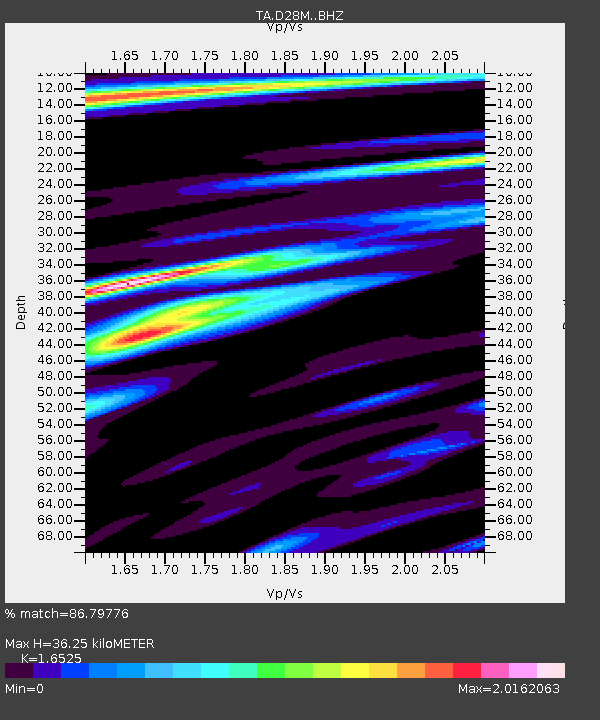
| Estimated Moho Depth: |
36.25 km |
| Estimated Crust Vp/Vs: |
1.65 |
| Assumed Crust Vp: |
6.316 km/s |
| Estimated Crust Vs: |
3.822 km/s |
| Estimated Crust Poisson's Ratio: |
0.21 |
|
| Radial Match: |
86.79776 % |
| Radial Bump: |
400 |
| Transverse Match: |
76.27148 % |
| Transverse Bump: |
400 |
| SOD ConfigId: |
13570011 |
| Insert Time: |
2019-05-02 15:18:32.590 +0000 |
| GWidth: |
2.5 |
| Max Bumps: |
400 |
| Tol: |
0.001 |
|

Signal To Noise
| Channel | StoN | STA | LTA |
| TA:D28M: :BHZ:20190302T03:30:45.475Z | 3.9568005 | 1.2819265E-6 | 3.2398057E-7 |
| TA:D28M: :BHN:20190302T03:30:45.475Z | 0.99982744 | 3.1181185E-7 | 3.1186568E-7 |
| TA:D28M: :BHE:20190302T03:30:45.475Z | 3.4334266 | 6.790619E-7 | 1.9777964E-7 |
| Arrivals |
| Ps | 4.0 SECOND |
| PpPs | 14 SECOND |
| PsPs/PpSs | 18 SECOND |


