You are here: Home > Network List > TA - USArray Transportable Network (new EarthScope stations) Stations List
> Station F17K Baldwin Penninsula, AK, USA > Earthquake Result Viewer
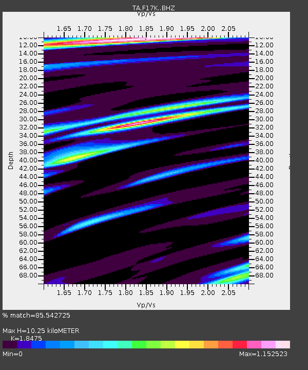
F17K Baldwin Penninsula, AK, USA - Earthquake Result Viewer
| Earthquake location: |
Off Coast Of Hokkaido, Japan |
| Earthquake latitude/longitude: |
41.9/146.9 |
| Earthquake time(UTC): |
2019/03/02 (061) 03:22:52 GMT |
| Earthquake Depth: |
10 km |
| Earthquake Magnitude: |
6.0 Mww |
| Earthquake Catalog/Contributor: |
NEIC PDE/us |
|
| Network: |
TA USArray Transportable Network (new EarthScope stations) |
| Station: |
F17K Baldwin Penninsula, AK, USA |
| Lat/Lon: |
66.44 N/161.25 W |
| Elevation: |
51 m |
|
| Distance: |
37.3 deg |
| Az: |
31.387 deg |
| Baz: |
255.203 deg |
| Ray Param: |
0.07619136 |
| Estimated Moho Depth: |
10.25 km |
| Estimated Crust Vp/Vs: |
1.85 |
| Assumed Crust Vp: |
6.276 km/s |
| Estimated Crust Vs: |
3.397 km/s |
| Estimated Crust Poisson's Ratio: |
0.29 |
|
| Radial Match: |
85.542725 % |
| Radial Bump: |
400 |
| Transverse Match: |
80.57349 % |
| Transverse Bump: |
400 |
| SOD ConfigId: |
13570011 |
| Insert Time: |
2019-05-02 15:18:44.038 +0000 |
| GWidth: |
2.5 |
| Max Bumps: |
400 |
| Tol: |
0.001 |
|

Signal To Noise
| Channel | StoN | STA | LTA |
| TA:F17K: :BHZ:20190302T03:29:34.249994Z | 10.641553 | 1.4289305E-6 | 1.3427838E-7 |
| TA:F17K: :BHN:20190302T03:29:34.249994Z | 1.8727975 | 4.08145E-7 | 2.1793335E-7 |
| TA:F17K: :BHE:20190302T03:29:34.249994Z | 4.194879 | 5.422091E-7 | 1.29255E-7 |
| Arrivals |
| Ps | 1.5 SECOND |
| PpPs | 4.3 SECOND |
| PsPs/PpSs | 5.8 SECOND |


