You are here: Home > Network List > TA - USArray Transportable Network (new EarthScope stations) Stations List
> Station F21K Alatna River, AK, USA > Earthquake Result Viewer
F21K Alatna River, AK, USA - Earthquake Result Viewer
| Earthquake location: |
Off Coast Of Hokkaido, Japan |
| Earthquake latitude/longitude: |
41.9/146.9 |
| Earthquake time(UTC): |
2019/03/02 (061) 03:22:52 GMT |
| Earthquake Depth: |
10 km |
| Earthquake Magnitude: |
6.0 Mww |
| Earthquake Catalog/Contributor: |
NEIC PDE/us |
|
| Network: |
TA USArray Transportable Network (new EarthScope stations) |
| Station: |
F21K Alatna River, AK, USA |
| Lat/Lon: |
67.22 N/153.48 W |
| Elevation: |
597 m |
|
| Distance: |
40.5 deg |
| Az: |
31.127 deg |
| Baz: |
262.136 deg |
| Ray Param: |
0.07436526 |
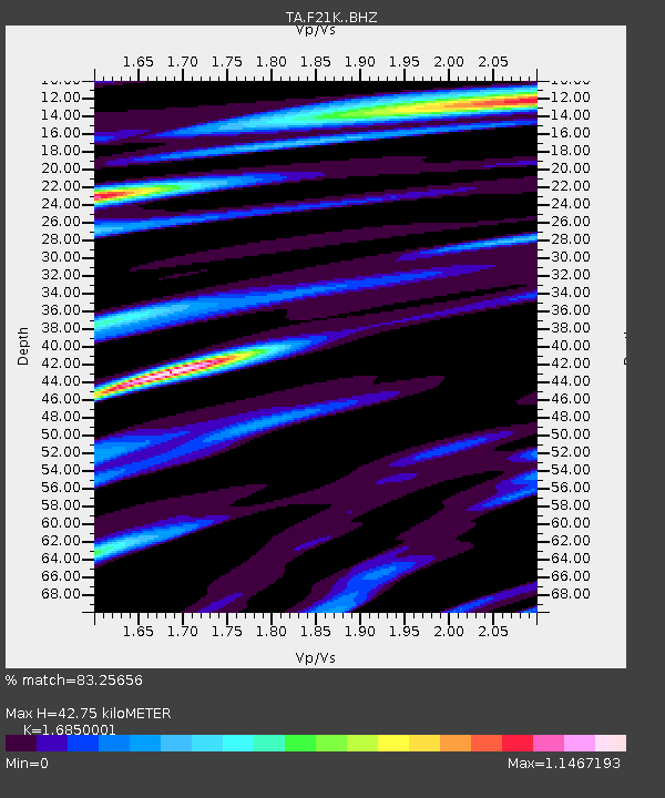
| Estimated Moho Depth: |
42.75 km |
| Estimated Crust Vp/Vs: |
1.69 |
| Assumed Crust Vp: |
6.455 km/s |
| Estimated Crust Vs: |
3.831 km/s |
| Estimated Crust Poisson's Ratio: |
0.23 |
|
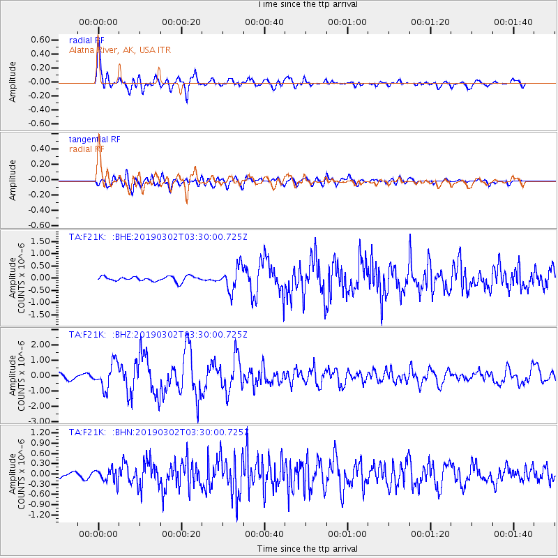
| Radial Match: |
83.25656 % |
| Radial Bump: |
400 |
| Transverse Match: |
70.55618 % |
| Transverse Bump: |
400 |
| SOD ConfigId: |
13570011 |
| Insert Time: |
2019-05-02 15:18:48.268 +0000 |
| GWidth: |
2.5 |
| Max Bumps: |
400 |
| Tol: |
0.001 |
|
Signal To Noise
| Channel | StoN | STA | LTA |
| TA:F21K: :BHZ:20190302T03:30:00.725Z | 5.2325726 | 8.6193074E-7 | 1.647241E-7 |
| TA:F21K: :BHN:20190302T03:30:00.725Z | 1.8632098 | 1.8796058E-7 | 1.0087999E-7 |
| TA:F21K: :BHE:20190302T03:30:00.725Z | 4.9876366 | 4.995109E-7 | 1.0014982E-7 |
| Arrivals |
| Ps | 4.9 SECOND |
| PpPs | 17 SECOND |
| PsPs/PpSs | 21 SECOND |


