You are here: Home > Network List > TA - USArray Transportable Network (new EarthScope stations) Stations List
> Station G21K Allakaket, AK, USA > Earthquake Result Viewer
G21K Allakaket, AK, USA - Earthquake Result Viewer
| Earthquake location: |
Off Coast Of Hokkaido, Japan |
| Earthquake latitude/longitude: |
41.9/146.9 |
| Earthquake time(UTC): |
2019/03/02 (061) 03:22:52 GMT |
| Earthquake Depth: |
10 km |
| Earthquake Magnitude: |
6.0 Mww |
| Earthquake Catalog/Contributor: |
NEIC PDE/us |
|
| Network: |
TA USArray Transportable Network (new EarthScope stations) |
| Station: |
G21K Allakaket, AK, USA |
| Lat/Lon: |
66.52 N/153.51 W |
| Elevation: |
446 m |
|
| Distance: |
40.4 deg |
| Az: |
32.21 deg |
| Baz: |
262.939 deg |
| Ray Param: |
0.07442315 |
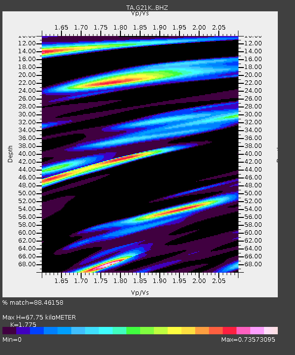
| Estimated Moho Depth: |
67.75 km |
| Estimated Crust Vp/Vs: |
1.77 |
| Assumed Crust Vp: |
6.455 km/s |
| Estimated Crust Vs: |
3.637 km/s |
| Estimated Crust Poisson's Ratio: |
0.27 |
|
| Radial Match: |
88.46158 % |
| Radial Bump: |
400 |
| Transverse Match: |
80.636925 % |
| Transverse Bump: |
400 |
| SOD ConfigId: |
13570011 |
| Insert Time: |
2019-05-02 15:18:59.262 +0000 |
| GWidth: |
2.5 |
| Max Bumps: |
400 |
| Tol: |
0.001 |
|
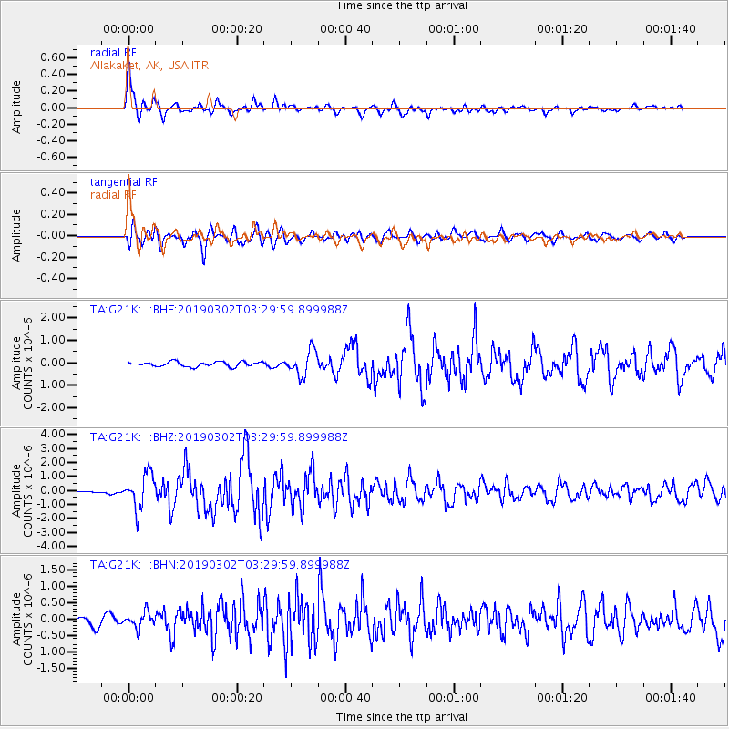
Signal To Noise
| Channel | StoN | STA | LTA |
| TA:G21K: :BHZ:20190302T03:29:59.899988Z | 7.4615364 | 1.234591E-6 | 1.6546069E-7 |
| TA:G21K: :BHN:20190302T03:29:59.899988Z | 1.8653078 | 2.3882842E-7 | 1.28037E-7 |
| TA:G21K: :BHE:20190302T03:29:59.899988Z | 5.357489 | 5.5784034E-7 | 1.04123465E-7 |
| Arrivals |
| Ps | 8.7 SECOND |
| PpPs | 27 SECOND |
| PsPs/PpSs | 36 SECOND |


