You are here: Home > Network List > TA - USArray Transportable Network (new EarthScope stations) Stations List
> Station H17K Granite Mountain, AK, USA > Earthquake Result Viewer
H17K Granite Mountain, AK, USA - Earthquake Result Viewer
| Earthquake location: |
Off Coast Of Hokkaido, Japan |
| Earthquake latitude/longitude: |
41.9/146.9 |
| Earthquake time(UTC): |
2019/03/02 (061) 03:22:52 GMT |
| Earthquake Depth: |
10 km |
| Earthquake Magnitude: |
6.0 Mww |
| Earthquake Catalog/Contributor: |
NEIC PDE/us |
|
| Network: |
TA USArray Transportable Network (new EarthScope stations) |
| Station: |
H17K Granite Mountain, AK, USA |
| Lat/Lon: |
64.94 N/159.91 W |
| Elevation: |
396 m |
|
| Distance: |
37.5 deg |
| Az: |
34.016 deg |
| Baz: |
258.509 deg |
| Ray Param: |
0.07608483 |
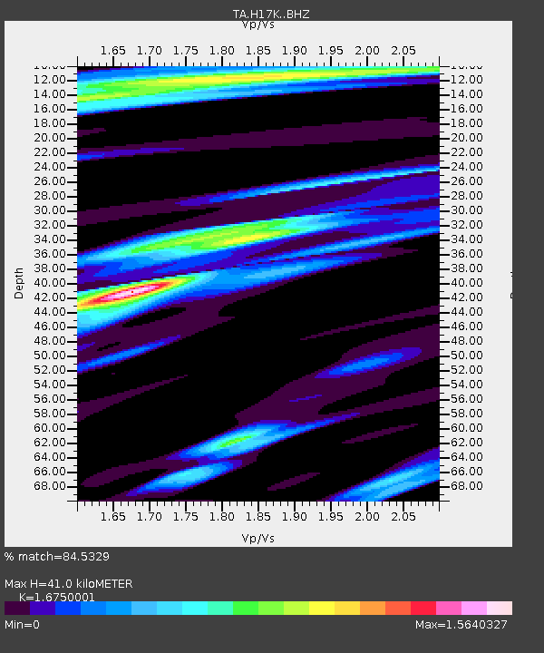
| Estimated Moho Depth: |
41.0 km |
| Estimated Crust Vp/Vs: |
1.68 |
| Assumed Crust Vp: |
6.1 km/s |
| Estimated Crust Vs: |
3.642 km/s |
| Estimated Crust Poisson's Ratio: |
0.22 |
|
| Radial Match: |
84.5329 % |
| Radial Bump: |
361 |
| Transverse Match: |
72.049324 % |
| Transverse Bump: |
400 |
| SOD ConfigId: |
13570011 |
| Insert Time: |
2019-05-02 15:19:04.836 +0000 |
| GWidth: |
2.5 |
| Max Bumps: |
400 |
| Tol: |
0.001 |
|

Signal To Noise
| Channel | StoN | STA | LTA |
| TA:H17K: :BHZ:20190302T03:29:35.925012Z | 5.564624 | 1.1888577E-6 | 2.1364566E-7 |
| TA:H17K: :BHN:20190302T03:29:35.925012Z | 2.0506818 | 2.8325198E-7 | 1.3812576E-7 |
| TA:H17K: :BHE:20190302T03:29:35.925012Z | 2.8555608 | 4.7791985E-7 | 1.6736462E-7 |
| Arrivals |
| Ps | 4.9 SECOND |
| PpPs | 17 SECOND |
| PsPs/PpSs | 22 SECOND |


