You are here: Home > Network List > TA - USArray Transportable Network (new EarthScope stations) Stations List
> Station R33M Jennings River, BC, CAN > Earthquake Result Viewer
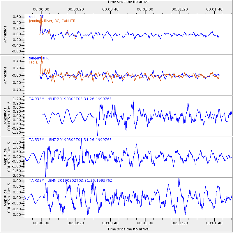
R33M Jennings River, BC, CAN - Earthquake Result Viewer
*The percent match for this event was below the threshold and hence no stack was calculated.
| Earthquake location: |
Off Coast Of Hokkaido, Japan |
| Earthquake latitude/longitude: |
41.9/146.9 |
| Earthquake time(UTC): |
2019/03/02 (061) 03:22:52 GMT |
| Earthquake Depth: |
10 km |
| Earthquake Magnitude: |
6.0 Mww |
| Earthquake Catalog/Contributor: |
NEIC PDE/us |
|
| Network: |
TA USArray Transportable Network (new EarthScope stations) |
| Station: |
R33M Jennings River, BC, CAN |
| Lat/Lon: |
59.39 N/130.97 W |
| Elevation: |
1437 m |
|
| Distance: |
51.3 deg |
| Az: |
40.462 deg |
| Baz: |
288.854 deg |
| Ray Param: |
$rayparam |
*The percent match for this event was below the threshold and hence was not used in the summary stack. |
|
| Radial Match: |
64.87546 % |
| Radial Bump: |
400 |
| Transverse Match: |
47.271122 % |
| Transverse Bump: |
381 |
| SOD ConfigId: |
13570011 |
| Insert Time: |
2019-05-02 15:20:28.946 +0000 |
| GWidth: |
2.5 |
| Max Bumps: |
400 |
| Tol: |
0.001 |
|
Signal To Noise
| Channel | StoN | STA | LTA |
| TA:R33M: :BHZ:20190302T03:31:26.199976Z | 5.084274 | 8.5048083E-7 | 1.6727677E-7 |
| TA:R33M: :BHN:20190302T03:31:26.199976Z | 2.0230122 | 3.292164E-7 | 1.6273574E-7 |
| TA:R33M: :BHE:20190302T03:31:26.199976Z | 2.1221776 | 5.7939303E-7 | 2.7301817E-7 |
| Arrivals |
| Ps | |
| PpPs | |
| PsPs/PpSs | |


