You are here: Home > Network List > TA - USArray Transportable Network (new EarthScope stations) Stations List
> Station P19A Cripple Cowboy Ranch, Baxter Pass, CO, USA > Earthquake Result Viewer
P19A Cripple Cowboy Ranch, Baxter Pass, CO, USA - Earthquake Result Viewer
| Earthquake location: |
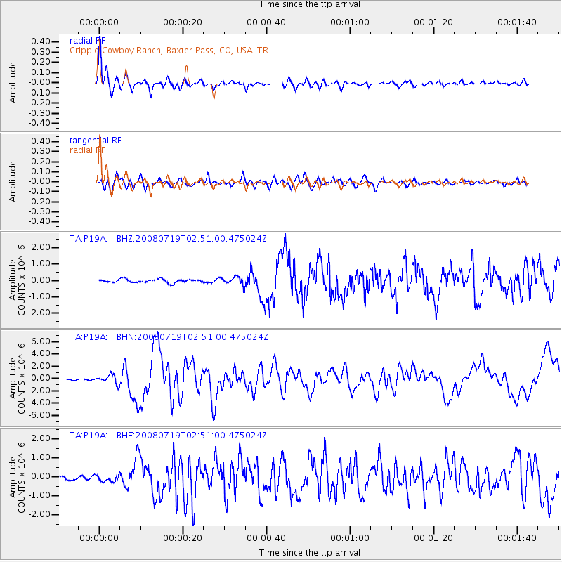
Off East Coast Of Honshu, Japan |
| Earthquake latitude/longitude: |
37.6/142.2 |
| Earthquake time(UTC): |
2008/07/19 (201) 02:39:28 GMT |
| Earthquake Depth: |
22 km |
| Earthquake Magnitude: |
6.2 MB, 7.0 MS, 7.0 MW, 6.9 MW |
| Earthquake Catalog/Contributor: |
WHDF/NEIC |
|
| Network: |
TA USArray Transportable Network (new EarthScope stations) |
| Station: |
P19A Cripple Cowboy Ranch, Baxter Pass, CO, USA |
| Lat/Lon: |
39.63 N/108.98 W |
| Elevation: |
2099 m |
|
| Distance: |
79.2 deg |
| Az: |
48.095 deg |
| Baz: |
310.007 deg |
| Ray Param: |
0.04911588 |
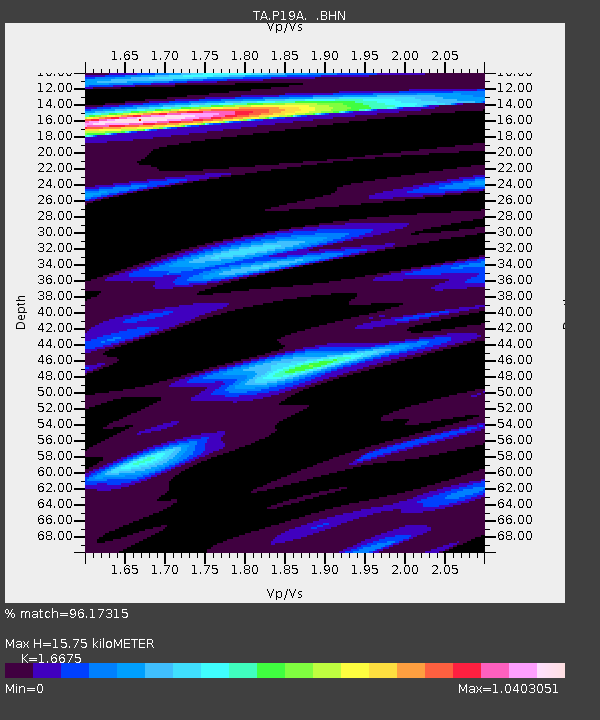
| Estimated Moho Depth: |
15.75 km |
| Estimated Crust Vp/Vs: |
1.67 |
| Assumed Crust Vp: |
6.291 km/s |
| Estimated Crust Vs: |
3.773 km/s |
| Estimated Crust Poisson's Ratio: |
0.22 |
|
| Radial Match: |
96.17315 % |
| Radial Bump: |
389 |
| Transverse Match: |
84.88818 % |
| Transverse Bump: |
400 |
| SOD ConfigId: |
2504 |
| Insert Time: |
2010-03-06 20:30:25.893 +0000 |
| GWidth: |
2.5 |
| Max Bumps: |
400 |
| Tol: |
0.001 |
|
Signal To Noise
| Channel | StoN | STA | LTA |
| TA:P19A: :BHN:20080719T02:51:00.475024Z | 6.456341 | 7.411878E-7 | 1.14799974E-7 |
| TA:P19A: :BHE:20080719T02:51:00.475024Z | 1.5770775 | 1.5819076E-7 | 1.00306266E-7 |
| TA:P19A: :BHZ:20080719T02:51:00.475024Z | 2.4117382 | 2.4915045E-7 | 1.03307414E-7 |
| Arrivals |
| Ps | 1.7 SECOND |
| PpPs | 6.5 SECOND |
| PsPs/PpSs | 8.2 SECOND |


