You are here: Home > Network List > II - Global Seismograph Network (GSN - IRIS/IDA) Stations List
> Station WRAB Tennant Creek, NT, Australia > Earthquake Result Viewer
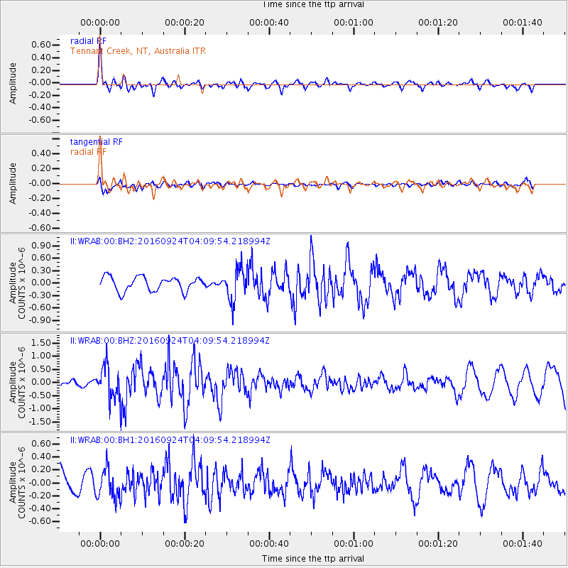
WRAB Tennant Creek, NT, Australia - Earthquake Result Viewer
*The percent match for this event was below the threshold and hence no stack was calculated.
| Earthquake location: |
South Of Kermadec Islands |
| Earthquake latitude/longitude: |
-32.6/-177.6 |
| Earthquake time(UTC): |
2016/09/24 (268) 04:02:13 GMT |
| Earthquake Depth: |
10 km |
| Earthquake Magnitude: |
5.8 MO |
| Earthquake Catalog/Contributor: |
NEIC PDE/NEIC ALERT |
|
| Network: |
II Global Seismograph Network (GSN - IRIS/IDA) |
| Station: |
WRAB Tennant Creek, NT, Australia |
| Lat/Lon: |
19.93 S/134.36 E |
| Elevation: |
366 m |
|
| Distance: |
44.6 deg |
| Az: |
274.113 deg |
| Baz: |
116.445 deg |
| Ray Param: |
$rayparam |
*The percent match for this event was below the threshold and hence was not used in the summary stack. |
|
| Radial Match: |
76.63141 % |
| Radial Bump: |
389 |
| Transverse Match: |
62.38727 % |
| Transverse Bump: |
400 |
| SOD ConfigId: |
1634031 |
| Insert Time: |
2016-10-08 04:03:04.952 +0000 |
| GWidth: |
2.5 |
| Max Bumps: |
400 |
| Tol: |
0.001 |
|
Signal To Noise
| Channel | StoN | STA | LTA |
| II:WRAB:00:BHZ:20160924T04:09:54.218994Z | 4.640333 | 6.40774E-7 | 1.3808793E-7 |
| II:WRAB:00:BH1:20160924T04:09:54.218994Z | 1.2677971 | 2.32182E-7 | 1.8313814E-7 |
| II:WRAB:00:BH2:20160924T04:09:54.218994Z | 2.2907019 | 3.8715203E-7 | 1.6901022E-7 |
| Arrivals |
| Ps | |
| PpPs | |
| PsPs/PpSs | |


