You are here: Home > Network List > TA - USArray Transportable Network (new EarthScope stations) Stations List
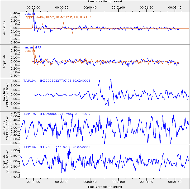
> Station P19A Cripple Cowboy Ranch, Baxter Pass, CO, USA > Earthquake Result Viewer
P19A Cripple Cowboy Ranch, Baxter Pass, CO, USA - Earthquake Result Viewer
| Earthquake location: |
Bonin Islands, Japan Region |
| Earthquake latitude/longitude: |
26.8/142.4 |
| Earthquake time(UTC): |
2008/02/27 (058) 06:54:20 GMT |
| Earthquake Depth: |
15 km |
| Earthquake Magnitude: |
5.8 MB, 6.1 MS, 6.2 MW, 6.2 MW |
| Earthquake Catalog/Contributor: |
WHDF/NEIC |
|
| Network: |
TA USArray Transportable Network (new EarthScope stations) |
| Station: |
P19A Cripple Cowboy Ranch, Baxter Pass, CO, USA |
| Lat/Lon: |
39.63 N/108.98 W |
| Elevation: |
2099 m |
|
| Distance: |
86.3 deg |
| Az: |
47.185 deg |
| Baz: |
301.908 deg |
| Ray Param: |
0.044167727 |
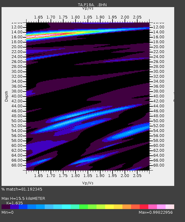
| Estimated Moho Depth: |
15.5 km |
| Estimated Crust Vp/Vs: |
1.63 |
| Assumed Crust Vp: |
6.291 km/s |
| Estimated Crust Vs: |
3.848 km/s |
| Estimated Crust Poisson's Ratio: |
0.20 |
|
| Radial Match: |
81.192345 % |
| Radial Bump: |
400 |
| Transverse Match: |
56.32272 % |
| Transverse Bump: |
400 |
| SOD ConfigId: |
2564 |
| Insert Time: |
2010-03-06 20:30:46.895 +0000 |
| GWidth: |
2.5 |
| Max Bumps: |
400 |
| Tol: |
0.001 |
|
Signal To Noise
| Channel | StoN | STA | LTA |
| TA:P19A: :BHN:20080227T07:06:30.024001Z | 1.5917157 | 3.2808381E-7 | 2.0611961E-7 |
| TA:P19A: :BHE:20080227T07:06:30.024001Z | 1.1810311 | 2.1782387E-7 | 1.8443534E-7 |
| TA:P19A: :BHZ:20080227T07:06:30.024001Z | 2.2909014 | 3.655786E-7 | 1.5957849E-7 |
| Arrivals |
| Ps | 1.6 SECOND |
| PpPs | 6.3 SECOND |
| PsPs/PpSs | 7.9 SECOND |


