You are here: Home > Network List > TA - USArray Transportable Network (new EarthScope stations) Stations List
> Station P19A Cripple Cowboy Ranch, Baxter Pass, CO, USA > Earthquake Result Viewer
P19A Cripple Cowboy Ranch, Baxter Pass, CO, USA - Earthquake Result Viewer

| Earthquake location: |
Hokkaido, Japan Region |
| Earthquake latitude/longitude: |
41.8/143.4 |
| Earthquake time(UTC): |
2009/06/05 (156) 03:30:33 GMT |
| Earthquake Depth: |
29 km |
| Earthquake Magnitude: |
6.0 MB, 6.3 MS, 6.4 MW, 6.4 MW |
| Earthquake Catalog/Contributor: |
WHDF/NEIC |
|
| Network: |
TA USArray Transportable Network (new EarthScope stations) |
| Station: |
P19A Cripple Cowboy Ranch, Baxter Pass, CO, USA |
| Lat/Lon: |
39.63 N/108.98 W |
| Elevation: |
2099 m |
|
| Distance: |
75.7 deg |
| Az: |
49.456 deg |
| Baz: |
312.653 deg |
| Ray Param: |
0.051485825 |
| Estimated Moho Depth: |
16.0 km |
| Estimated Crust Vp/Vs: |
1.62 |
| Assumed Crust Vp: |
6.291 km/s |
| Estimated Crust Vs: |
3.883 km/s |
| Estimated Crust Poisson's Ratio: |
0.19 |
|
| Radial Match: |
91.58222 % |
| Radial Bump: |
400 |
| Transverse Match: |
77.089035 % |
| Transverse Bump: |
400 |
| SOD ConfigId: |
2648 |
| Insert Time: |
2010-03-06 20:31:40.082 +0000 |
| GWidth: |
2.5 |
| Max Bumps: |
400 |
| Tol: |
0.001 |
|
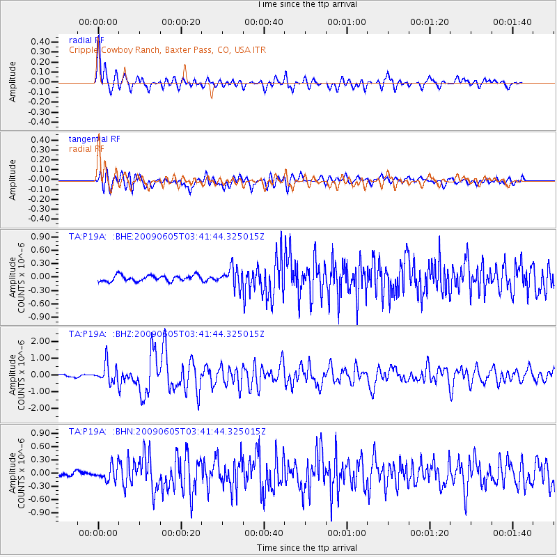
Signal To Noise
| Channel | StoN | STA | LTA |
| TA:P19A: :BHZ:20090605T03:41:44.325015Z | 8.479735 | 6.0210596E-7 | 7.1005275E-8 |
| TA:P19A: :BHN:20090605T03:41:44.325015Z | 5.3372803 | 1.7610108E-7 | 3.299454E-8 |
| TA:P19A: :BHE:20090605T03:41:44.325015Z | 3.3769186 | 2.1939833E-7 | 6.496998E-8 |
| Arrivals |
| Ps | 1.6 SECOND |
| PpPs | 6.4 SECOND |
| PsPs/PpSs | 8.1 SECOND |


