You are here: Home > Network List > TA - USArray Transportable Network (new EarthScope stations) Stations List
> Station P19A Cripple Cowboy Ranch, Baxter Pass, CO, USA > Earthquake Result Viewer
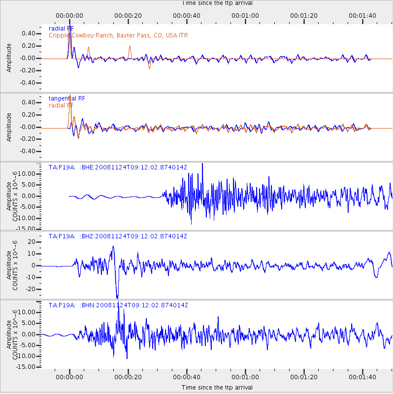
P19A Cripple Cowboy Ranch, Baxter Pass, CO, USA - Earthquake Result Viewer
| Earthquake location: |
Sea Of Okhotsk |
| Earthquake latitude/longitude: |
54.2/154.3 |
| Earthquake time(UTC): |
2008/11/24 (329) 09:02:58 GMT |
| Earthquake Depth: |
492 km |
| Earthquake Magnitude: |
6.5 MB, 7.3 MW, 7.3 MW |
| Earthquake Catalog/Contributor: |
WHDF/NEIC |
|
| Network: |
TA USArray Transportable Network (new EarthScope stations) |
| Station: |
P19A Cripple Cowboy Ranch, Baxter Pass, CO, USA |
| Lat/Lon: |
39.63 N/108.98 W |
| Elevation: |
2099 m |
|
| Distance: |
62.5 deg |
| Az: |
59.814 deg |
| Baz: |
318.882 deg |
| Ray Param: |
0.05836942 |
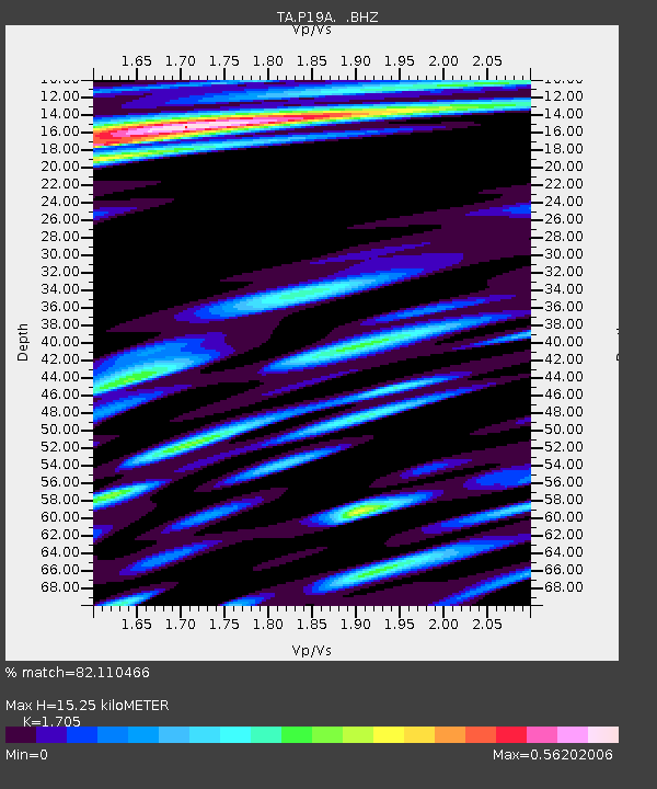
| Estimated Moho Depth: |
15.25 km |
| Estimated Crust Vp/Vs: |
1.71 |
| Assumed Crust Vp: |
6.291 km/s |
| Estimated Crust Vs: |
3.69 km/s |
| Estimated Crust Poisson's Ratio: |
0.24 |
|
| Radial Match: |
82.110466 % |
| Radial Bump: |
353 |
| Transverse Match: |
67.21353 % |
| Transverse Bump: |
400 |
| SOD ConfigId: |
2658 |
| Insert Time: |
2010-03-06 20:31:41.863 +0000 |
| GWidth: |
2.5 |
| Max Bumps: |
400 |
| Tol: |
0.001 |
|
Signal To Noise
| Channel | StoN | STA | LTA |
| TA:P19A: :BHZ:20081124T09:12:02.874014Z | 16.542389 | 3.3376482E-6 | 2.0176337E-7 |
| TA:P19A: :BHN:20081124T09:12:02.874014Z | 3.5259132 | 9.1199615E-7 | 2.5865532E-7 |
| TA:P19A: :BHE:20081124T09:12:02.874014Z | 2.9913914 | 1.3329064E-6 | 4.4558075E-7 |
| Arrivals |
| Ps | 1.8 SECOND |
| PpPs | 6.3 SECOND |
| PsPs/PpSs | 8.1 SECOND |


