You are here: Home > Network List > TA - USArray Transportable Network (new EarthScope stations) Stations List
> Station E21K Killik River, AK, USA > Earthquake Result Viewer
E21K Killik River, AK, USA - Earthquake Result Viewer
| Earthquake location: |
Eastern New Guinea Reg., P.N.G. |
| Earthquake latitude/longitude: |
-5.2/146.2 |
| Earthquake time(UTC): |
2019/03/04 (063) 10:06:01 GMT |
| Earthquake Depth: |
10 km |
| Earthquake Magnitude: |
5.9 Mww |
| Earthquake Catalog/Contributor: |
NEIC PDE/us |
|
| Network: |
TA USArray Transportable Network (new EarthScope stations) |
| Station: |
E21K Killik River, AK, USA |
| Lat/Lon: |
68.44 N/153.97 W |
| Elevation: |
653 m |
|
| Distance: |
84.2 deg |
| Az: |
18.735 deg |
| Baz: |
239.936 deg |
| Ray Param: |
0.045637142 |
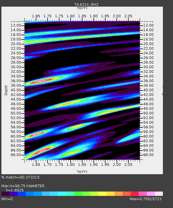
| Estimated Moho Depth: |
58.75 km |
| Estimated Crust Vp/Vs: |
1.65 |
| Assumed Crust Vp: |
6.221 km/s |
| Estimated Crust Vs: |
3.765 km/s |
| Estimated Crust Poisson's Ratio: |
0.21 |
|
| Radial Match: |
80.373215 % |
| Radial Bump: |
400 |
| Transverse Match: |
72.39319 % |
| Transverse Bump: |
400 |
| SOD ConfigId: |
13570011 |
| Insert Time: |
2019-05-02 15:46:13.259 +0000 |
| GWidth: |
2.5 |
| Max Bumps: |
400 |
| Tol: |
0.001 |
|

Signal To Noise
| Channel | StoN | STA | LTA |
| TA:E21K: :BHZ:20190304T10:18:01.300007Z | 6.323692 | 6.901161E-7 | 1.0913183E-7 |
| TA:E21K: :BHN:20190304T10:18:01.300007Z | 1.3882407 | 1.4991757E-7 | 1.0799104E-7 |
| TA:E21K: :BHE:20190304T10:18:01.300007Z | 1.3551067 | 1.4237048E-7 | 1.0506219E-7 |
| Arrivals |
| Ps | 6.3 SECOND |
| PpPs | 24 SECOND |
| PsPs/PpSs | 31 SECOND |


