You are here: Home > Network List > TA - USArray Transportable Network (new EarthScope stations) Stations List
> Station P19A Cripple Cowboy Ranch, Baxter Pass, CO, USA > Earthquake Result Viewer
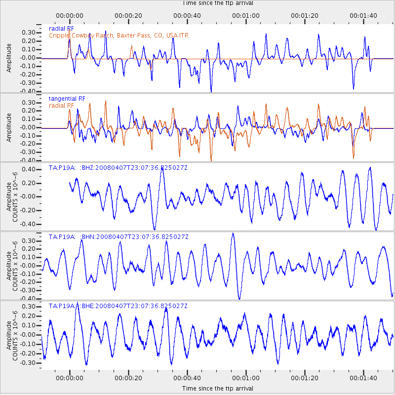
P19A Cripple Cowboy Ranch, Baxter Pass, CO, USA - Earthquake Result Viewer
*The percent match for this event was below the threshold and hence no stack was calculated.
| Earthquake location: |
Vanuatu Islands |
| Earthquake latitude/longitude: |
-20.0/168.5 |
| Earthquake time(UTC): |
2008/04/07 (098) 22:54:36 GMT |
| Earthquake Depth: |
10 km |
| Earthquake Magnitude: |
5.5 MB, 5.5 MS, 5.8 MW, 5.7 MW |
| Earthquake Catalog/Contributor: |
WHDF/NEIC |
|
| Network: |
TA USArray Transportable Network (new EarthScope stations) |
| Station: |
P19A Cripple Cowboy Ranch, Baxter Pass, CO, USA |
| Lat/Lon: |
39.63 N/108.98 W |
| Elevation: |
2099 m |
|
| Distance: |
97.0 deg |
| Az: |
50.487 deg |
| Baz: |
250.003 deg |
| Ray Param: |
$rayparam |
*The percent match for this event was below the threshold and hence was not used in the summary stack. |
|
| Radial Match: |
63.40952 % |
| Radial Bump: |
400 |
| Transverse Match: |
47.75926 % |
| Transverse Bump: |
400 |
| SOD ConfigId: |
2504 |
| Insert Time: |
2010-03-06 20:34:06.298 +0000 |
| GWidth: |
2.5 |
| Max Bumps: |
400 |
| Tol: |
0.001 |
|
Signal To Noise
| Channel | StoN | STA | LTA |
| TA:P19A: :BHN:20080407T23:07:36.825027Z | 2.6444495 | 1.8932266E-7 | 7.159247E-8 |
| TA:P19A: :BHE:20080407T23:07:36.825027Z | 1.6112359 | 1.8330752E-7 | 1.13768266E-7 |
| TA:P19A: :BHZ:20080407T23:07:36.825027Z | 1.8667392 | 2.503703E-7 | 1.3412173E-7 |
| Arrivals |
| Ps | |
| PpPs | |
| PsPs/PpSs | |


