You are here: Home > Network List > AU - Australian Seismological Centre Stations List
> Station WRKA Warrakurna, Western Australia > Earthquake Result Viewer
WRKA Warrakurna, Western Australia - Earthquake Result Viewer
| Earthquake location: |
South Of Kermadec Islands |
| Earthquake latitude/longitude: |
-32.0/-177.9 |
| Earthquake time(UTC): |
2019/03/06 (065) 15:46:14 GMT |
| Earthquake Depth: |
29 km |
| Earthquake Magnitude: |
6.4 Mww |
| Earthquake Catalog/Contributor: |
NEIC PDE/us |
|
| Network: |
AU Australian Seismological Centre |
| Station: |
WRKA Warrakurna, Western Australia |
| Lat/Lon: |
25.04 S/128.30 E |
| Elevation: |
622 m |
|
| Distance: |
47.4 deg |
| Az: |
264.158 deg |
| Baz: |
111.329 deg |
| Ray Param: |
0.06996267 |
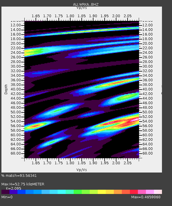
| Estimated Moho Depth: |
52.75 km |
| Estimated Crust Vp/Vs: |
2.10 |
| Assumed Crust Vp: |
6.51 km/s |
| Estimated Crust Vs: |
3.108 km/s |
| Estimated Crust Poisson's Ratio: |
0.35 |
|
| Radial Match: |
93.56341 % |
| Radial Bump: |
307 |
| Transverse Match: |
78.86142 % |
| Transverse Bump: |
400 |
| SOD ConfigId: |
13570011 |
| Insert Time: |
2019-05-02 16:06:43.164 +0000 |
| GWidth: |
2.5 |
| Max Bumps: |
400 |
| Tol: |
0.001 |
|

Signal To Noise
| Channel | StoN | STA | LTA |
| AU:WRKA: :BHZ:20190306T15:54:15.794012Z | 8.615855 | 2.7347855E-6 | 3.174131E-7 |
| AU:WRKA: :BHN:20190306T15:54:15.794012Z | 3.9039605 | 6.5419783E-7 | 1.6757286E-7 |
| AU:WRKA: :BHE:20190306T15:54:15.794012Z | 7.117131 | 1.4975609E-6 | 2.1041636E-7 |
| Arrivals |
| Ps | 9.4 SECOND |
| PpPs | 24 SECOND |
| PsPs/PpSs | 33 SECOND |


