You are here: Home > Network List > UW - Pacific Northwest Regional Seismic Network Stations List
> Station FISH Seaside, OR, USA > Earthquake Result Viewer
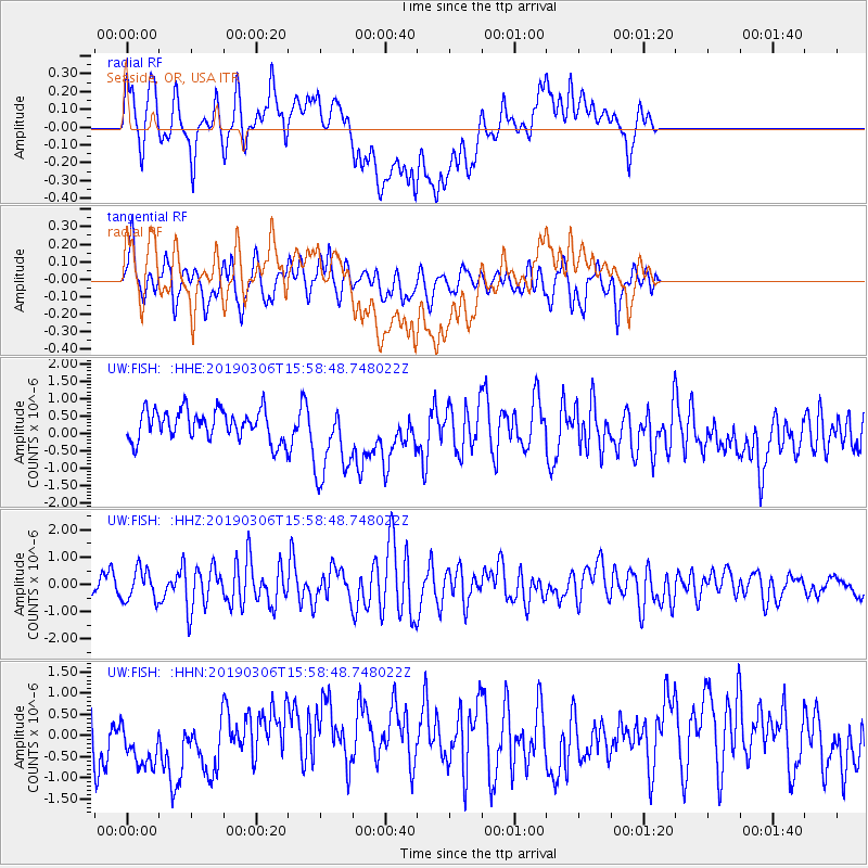
FISH Seaside, OR, USA - Earthquake Result Viewer
*The percent match for this event was below the threshold and hence no stack was calculated.
| Earthquake location: |
South Of Kermadec Islands |
| Earthquake latitude/longitude: |
-32.0/-177.9 |
| Earthquake time(UTC): |
2019/03/06 (065) 15:46:14 GMT |
| Earthquake Depth: |
29 km |
| Earthquake Magnitude: |
6.4 Mww |
| Earthquake Catalog/Contributor: |
NEIC PDE/us |
|
| Network: |
UW Pacific Northwest Regional Seismic Network |
| Station: |
FISH Seaside, OR, USA |
| Lat/Lon: |
45.93 N/123.56 W |
| Elevation: |
325 m |
|
| Distance: |
91.8 deg |
| Az: |
34.557 deg |
| Baz: |
223.655 deg |
| Ray Param: |
$rayparam |
*The percent match for this event was below the threshold and hence was not used in the summary stack. |
|
| Radial Match: |
49.142937 % |
| Radial Bump: |
400 |
| Transverse Match: |
51.811756 % |
| Transverse Bump: |
400 |
| SOD ConfigId: |
13570011 |
| Insert Time: |
2019-05-02 16:10:57.848 +0000 |
| GWidth: |
2.5 |
| Max Bumps: |
400 |
| Tol: |
0.001 |
|
Signal To Noise
| Channel | StoN | STA | LTA |
| UW:FISH: :HHZ:20190306T15:58:48.748022Z | 1.9820662 | 5.673938E-7 | 2.862638E-7 |
| UW:FISH: :HHN:20190306T15:58:48.748022Z | 1.6065356 | 7.9212447E-7 | 4.930638E-7 |
| UW:FISH: :HHE:20190306T15:58:48.748022Z | 2.6389015 | 1.1471951E-6 | 4.347245E-7 |
| Arrivals |
| Ps | |
| PpPs | |
| PsPs/PpSs | |


