You are here: Home > Network List > IU - Global Seismograph Network (GSN - IRIS/USGS) Stations List
> Station PMG Port Moresby, New Guinea > Earthquake Result Viewer
PMG Port Moresby, New Guinea - Earthquake Result Viewer
*The percent match for this event was below the threshold and hence no stack was calculated.
| Earthquake location: |
South Of Kermadec Islands |
| Earthquake latitude/longitude: |
-32.1/-177.9 |
| Earthquake time(UTC): |
2019/03/06 (065) 18:42:50 GMT |
| Earthquake Depth: |
10 km |
| Earthquake Magnitude: |
5.3 Ms_20 |
| Earthquake Catalog/Contributor: |
NEIC PDE/us |
|
| Network: |
IU Global Seismograph Network (GSN - IRIS/USGS) |
| Station: |
PMG Port Moresby, New Guinea |
| Lat/Lon: |
9.40 S/147.16 E |
| Elevation: |
90 m |
|
| Distance: |
39.4 deg |
| Az: |
297.166 deg |
| Baz: |
130.081 deg |
| Ray Param: |
$rayparam |
*The percent match for this event was below the threshold and hence was not used in the summary stack. |
|
| Radial Match: |
48.79927 % |
| Radial Bump: |
400 |
| Transverse Match: |
50.562687 % |
| Transverse Bump: |
400 |
| SOD ConfigId: |
13570011 |
| Insert Time: |
2019-05-02 16:14:29.362 +0000 |
| GWidth: |
2.5 |
| Max Bumps: |
400 |
| Tol: |
0.001 |
|
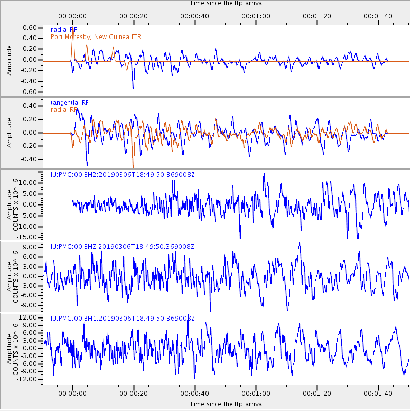
Signal To Noise
| Channel | StoN | STA | LTA |
| IU:PMG:00:BHZ:20190306T18:49:50.369008Z | 1.0680113 | 3.0055146E-6 | 2.8141224E-6 |
| IU:PMG:00:BH1:20190306T18:49:50.369008Z | 1.393609 | 4.169719E-6 | 2.9920293E-6 |
| IU:PMG:00:BH2:20190306T18:49:50.369008Z | 2.365776 | 4.446938E-6 | 1.8796953E-6 |
| Arrivals |
| Ps | |
| PpPs | |
| PsPs/PpSs | |


