You are here: Home > Network List > TA - USArray Transportable Network (new EarthScope stations) Stations List
> Station P19A Cripple Cowboy Ranch, Baxter Pass, CO, USA > Earthquake Result Viewer
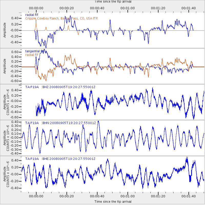
P19A Cripple Cowboy Ranch, Baxter Pass, CO, USA - Earthquake Result Viewer
*The percent match for this event was below the threshold and hence no stack was calculated.
| Earthquake location: |
North Of Ascension Island |
| Earthquake latitude/longitude: |
-1.2/-14.0 |
| Earthquake time(UTC): |
2008/09/05 (249) 19:07:38 GMT |
| Earthquake Depth: |
10 km |
| Earthquake Magnitude: |
5.5 MB, 5.5 MS, 5.8 MW, 5.8 MW |
| Earthquake Catalog/Contributor: |
WHDF/NEIC |
|
| Network: |
TA USArray Transportable Network (new EarthScope stations) |
| Station: |
P19A Cripple Cowboy Ranch, Baxter Pass, CO, USA |
| Lat/Lon: |
39.63 N/108.98 W |
| Elevation: |
2099 m |
|
| Distance: |
94.6 deg |
| Az: |
309.486 deg |
| Baz: |
87.702 deg |
| Ray Param: |
$rayparam |
*The percent match for this event was below the threshold and hence was not used in the summary stack. |
|
| Radial Match: |
39.95784 % |
| Radial Bump: |
400 |
| Transverse Match: |
45.79715 % |
| Transverse Bump: |
400 |
| SOD ConfigId: |
2560 |
| Insert Time: |
2010-03-06 20:34:44.430 +0000 |
| GWidth: |
2.5 |
| Max Bumps: |
400 |
| Tol: |
0.001 |
|
Signal To Noise
| Channel | StoN | STA | LTA |
| TA:P19A: :BHN:20080905T19:20:27.55001Z | 1.6378444 | 2.0789138E-7 | 1.2692986E-7 |
| TA:P19A: :BHE:20080905T19:20:27.55001Z | 1.04675 | 1.4693897E-7 | 1.4037637E-7 |
| TA:P19A: :BHZ:20080905T19:20:27.55001Z | 1.0054948 | 1.8127622E-7 | 1.802856E-7 |
| Arrivals |
| Ps | |
| PpPs | |
| PsPs/PpSs | |


