You are here: Home > Network List > TA - USArray Transportable Network (new EarthScope stations) Stations List
> Station S20A Disappointment Valley, Cahone, CO, USA > Earthquake Result Viewer
S20A Disappointment Valley, Cahone, CO, USA - Earthquake Result Viewer
| Earthquake location: |
Fiji Islands Region |
| Earthquake latitude/longitude: |
-17.3/-177.3 |
| Earthquake time(UTC): |
2008/07/19 (201) 22:39:52 GMT |
| Earthquake Depth: |
391 km |
| Earthquake Magnitude: |
5.9 MB, 6.4 MW, 6.4 MW |
| Earthquake Catalog/Contributor: |
WHDF/NEIC |
|
| Network: |
TA USArray Transportable Network (new EarthScope stations) |
| Station: |
S20A Disappointment Valley, Cahone, CO, USA |
| Lat/Lon: |
37.83 N/108.36 W |
| Elevation: |
2355 m |
|
| Distance: |
84.8 deg |
| Az: |
47.907 deg |
| Baz: |
243.521 deg |
| Ray Param: |
0.04419541 |
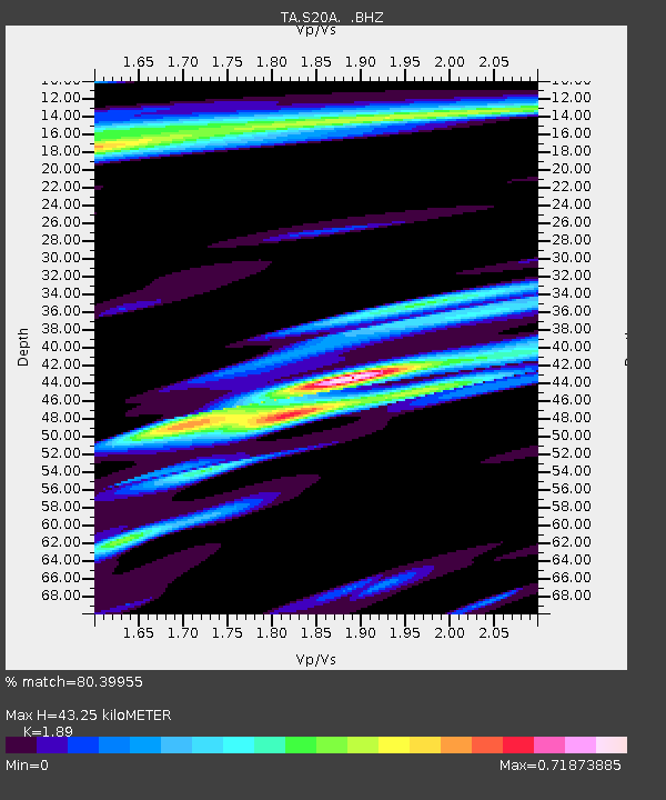
| Estimated Moho Depth: |
43.25 km |
| Estimated Crust Vp/Vs: |
1.89 |
| Assumed Crust Vp: |
6.476 km/s |
| Estimated Crust Vs: |
3.426 km/s |
| Estimated Crust Poisson's Ratio: |
0.31 |
|
| Radial Match: |
80.39955 % |
| Radial Bump: |
400 |
| Transverse Match: |
70.611496 % |
| Transverse Bump: |
400 |
| SOD ConfigId: |
2504 |
| Insert Time: |
2010-03-06 20:34:59.978 +0000 |
| GWidth: |
2.5 |
| Max Bumps: |
400 |
| Tol: |
0.001 |
|

Signal To Noise
| Channel | StoN | STA | LTA |
| TA:S20A: :BHZ:20080719T22:51:13.025012Z | 18.759588 | 1.2597344E-6 | 6.71515E-8 |
| TA:S20A: :BHN:20080719T22:51:13.025012Z | 2.8388162 | 2.2631781E-7 | 7.97226E-8 |
| TA:S20A: :BHE:20080719T22:51:13.025012Z | 5.7863917 | 5.4053896E-7 | 9.341555E-8 |
| Arrivals |
| Ps | 6.1 SECOND |
| PpPs | 19 SECOND |
| PsPs/PpSs | 25 SECOND |


