You are here: Home > Network List > TA - USArray Transportable Network (new EarthScope stations) Stations List
> Station S20A Disappointment Valley, Cahone, CO, USA > Earthquake Result Viewer
S20A Disappointment Valley, Cahone, CO, USA - Earthquake Result Viewer

| Earthquake location: |
Lake Baykal Region, Russia |
| Earthquake latitude/longitude: |
51.6/104.2 |
| Earthquake time(UTC): |
2008/08/27 (240) 01:35:32 GMT |
| Earthquake Depth: |
16 km |
| Earthquake Magnitude: |
5.8 MB, 6.2 MS, 6.2 MW, 6.2 MW |
| Earthquake Catalog/Contributor: |
WHDF/NEIC |
|
| Network: |
TA USArray Transportable Network (new EarthScope stations) |
| Station: |
S20A Disappointment Valley, Cahone, CO, USA |
| Lat/Lon: |
37.83 N/108.36 W |
| Elevation: |
2355 m |
|
| Distance: |
86.5 deg |
| Az: |
25.243 deg |
| Baz: |
340.375 deg |
| Ray Param: |
0.043998137 |
| Estimated Moho Depth: |
16.5 km |
| Estimated Crust Vp/Vs: |
1.60 |
| Assumed Crust Vp: |
6.476 km/s |
| Estimated Crust Vs: |
4.047 km/s |
| Estimated Crust Poisson's Ratio: |
0.18 |
|
| Radial Match: |
84.81587 % |
| Radial Bump: |
400 |
| Transverse Match: |
84.19709 % |
| Transverse Bump: |
400 |
| SOD ConfigId: |
2504 |
| Insert Time: |
2010-03-06 20:35:05.945 +0000 |
| GWidth: |
2.5 |
| Max Bumps: |
400 |
| Tol: |
0.001 |
|
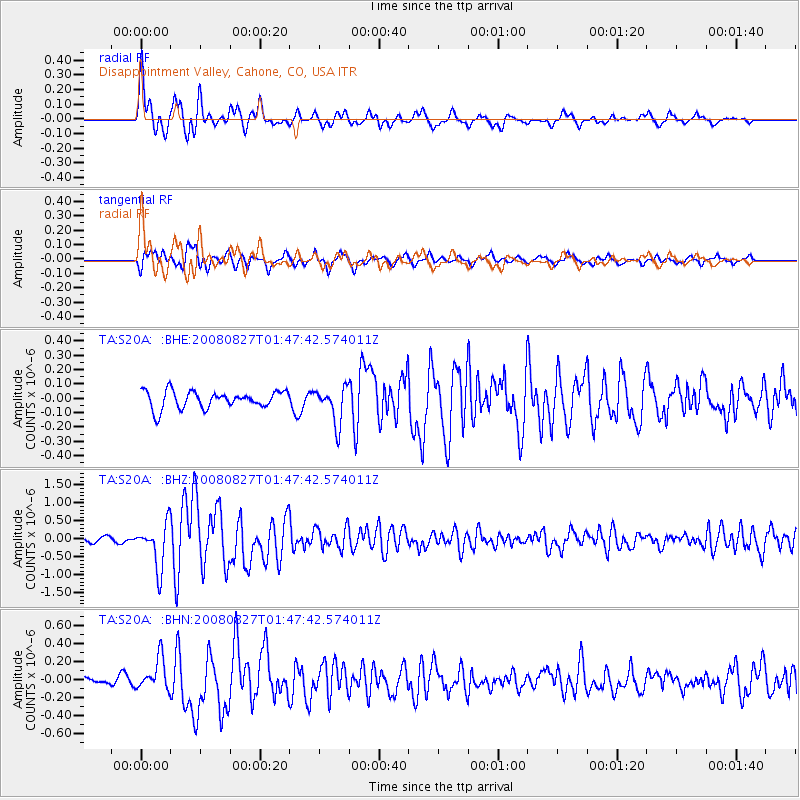
Signal To Noise
| Channel | StoN | STA | LTA |
| TA:S20A: :BHZ:20080827T01:47:42.574011Z | 10.362336 | 6.145987E-7 | 5.931083E-8 |
| TA:S20A: :BHN:20080827T01:47:42.574011Z | 2.986478 | 1.758386E-7 | 5.8878246E-8 |
| TA:S20A: :BHE:20080827T01:47:42.574011Z | 2.110651 | 1.2665896E-7 | 6.0009434E-8 |
| Arrivals |
| Ps | 1.6 SECOND |
| PpPs | 6.5 SECOND |
| PsPs/PpSs | 8.0 SECOND |


