You are here: Home > Network List > TA - USArray Transportable Network (new EarthScope stations) Stations List
> Station E20K Nigu River, AK, USA > Earthquake Result Viewer
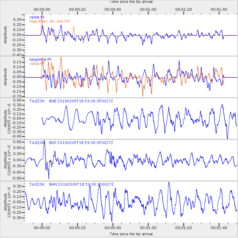
E20K Nigu River, AK, USA - Earthquake Result Viewer
*The percent match for this event was below the threshold and hence no stack was calculated.
| Earthquake location: |
New Guinea, Papua New Guinea |
| Earthquake latitude/longitude: |
-4.1/142.9 |
| Earthquake time(UTC): |
2019/03/06 (065) 18:47:25 GMT |
| Earthquake Depth: |
129 km |
| Earthquake Magnitude: |
5.6 Mww |
| Earthquake Catalog/Contributor: |
NEIC PDE/us |
|
| Network: |
TA USArray Transportable Network (new EarthScope stations) |
| Station: |
E20K Nigu River, AK, USA |
| Lat/Lon: |
68.26 N/156.19 W |
| Elevation: |
866 m |
|
| Distance: |
83.4 deg |
| Az: |
19.129 deg |
| Baz: |
241.316 deg |
| Ray Param: |
$rayparam |
*The percent match for this event was below the threshold and hence was not used in the summary stack. |
|
| Radial Match: |
59.91181 % |
| Radial Bump: |
400 |
| Transverse Match: |
59.664528 % |
| Transverse Bump: |
400 |
| SOD ConfigId: |
13570011 |
| Insert Time: |
2019-05-02 16:20:18.711 +0000 |
| GWidth: |
2.5 |
| Max Bumps: |
400 |
| Tol: |
0.001 |
|
Signal To Noise
| Channel | StoN | STA | LTA |
| TA:E20K: :BHZ:20190306T18:59:06.950027Z | 4.1322308 | 4.452592E-7 | 1.0775275E-7 |
| TA:E20K: :BHN:20190306T18:59:06.950027Z | 1.089722 | 1.03091296E-7 | 9.4603294E-8 |
| TA:E20K: :BHE:20190306T18:59:06.950027Z | 1.1852238 | 1.3514747E-7 | 1.1402696E-7 |
| Arrivals |
| Ps | |
| PpPs | |
| PsPs/PpSs | |


