You are here: Home > Network List > TA - USArray Transportable Network (new EarthScope stations) Stations List
> Station S20A Disappointment Valley, Cahone, CO, USA > Earthquake Result Viewer
S20A Disappointment Valley, Cahone, CO, USA - Earthquake Result Viewer
| Earthquake location: |
Tonga Islands |
| Earthquake latitude/longitude: |
-16.3/-173.5 |
| Earthquake time(UTC): |
2009/10/02 (275) 01:07:39 GMT |
| Earthquake Depth: |
8.0 km |
| Earthquake Magnitude: |
6.1 MB, 6.0 MS, 6.1 MW, 6.1 MW |
| Earthquake Catalog/Contributor: |
WHDF/NEIC |
|
| Network: |
TA USArray Transportable Network (new EarthScope stations) |
| Station: |
S20A Disappointment Valley, Cahone, CO, USA |
| Lat/Lon: |
37.83 N/108.36 W |
| Elevation: |
2355 m |
|
| Distance: |
81.4 deg |
| Az: |
46.587 deg |
| Baz: |
241.743 deg |
| Ray Param: |
0.047605593 |
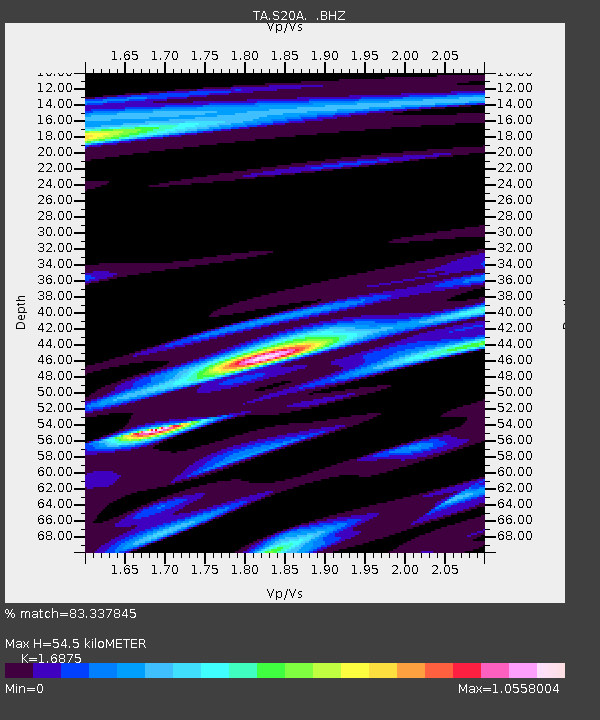
| Estimated Moho Depth: |
54.5 km |
| Estimated Crust Vp/Vs: |
1.69 |
| Assumed Crust Vp: |
6.476 km/s |
| Estimated Crust Vs: |
3.838 km/s |
| Estimated Crust Poisson's Ratio: |
0.23 |
|
| Radial Match: |
83.337845 % |
| Radial Bump: |
400 |
| Transverse Match: |
78.6885 % |
| Transverse Bump: |
400 |
| SOD ConfigId: |
2622 |
| Insert Time: |
2010-03-06 20:35:39.431 +0000 |
| GWidth: |
2.5 |
| Max Bumps: |
400 |
| Tol: |
0.001 |
|

Signal To Noise
| Channel | StoN | STA | LTA |
| TA:S20A: :BHZ:20091002T01:19:25.174001Z | 4.436116 | 5.8154563E-7 | 1.3109342E-7 |
| TA:S20A: :BHN:20091002T01:19:25.174001Z | 0.659663 | 5.1776713E-8 | 7.848964E-8 |
| TA:S20A: :BHE:20091002T01:19:25.174001Z | 1.2929413 | 1.9037654E-7 | 1.4724299E-7 |
| Arrivals |
| Ps | 6.0 SECOND |
| PpPs | 22 SECOND |
| PsPs/PpSs | 28 SECOND |


