You are here: Home > Network List > TA - USArray Transportable Network (new EarthScope stations) Stations List
> Station S20A Disappointment Valley, Cahone, CO, USA > Earthquake Result Viewer
S20A Disappointment Valley, Cahone, CO, USA - Earthquake Result Viewer

| Earthquake location: |
Ryukyu Islands, Japan |
| Earthquake latitude/longitude: |
29.2/129.8 |
| Earthquake time(UTC): |
2009/10/30 (303) 07:03:39 GMT |
| Earthquake Depth: |
34 km |
| Earthquake Magnitude: |
6.3 MB, 6.8 MS, 6.8 MW, 6.8 MW |
| Earthquake Catalog/Contributor: |
WHDF/NEIC |
|
| Network: |
TA USArray Transportable Network (new EarthScope stations) |
| Station: |
S20A Disappointment Valley, Cahone, CO, USA |
| Lat/Lon: |
37.83 N/108.36 W |
| Elevation: |
2355 m |
|
| Distance: |
93.9 deg |
| Az: |
42.387 deg |
| Baz: |
311.906 deg |
| Ray Param: |
0.041145578 |
| Estimated Moho Depth: |
23.0 km |
| Estimated Crust Vp/Vs: |
1.88 |
| Assumed Crust Vp: |
6.476 km/s |
| Estimated Crust Vs: |
3.454 km/s |
| Estimated Crust Poisson's Ratio: |
0.30 |
|
| Radial Match: |
81.34721 % |
| Radial Bump: |
400 |
| Transverse Match: |
58.508495 % |
| Transverse Bump: |
400 |
| SOD ConfigId: |
2622 |
| Insert Time: |
2010-03-06 20:35:44.607 +0000 |
| GWidth: |
2.5 |
| Max Bumps: |
400 |
| Tol: |
0.001 |
|
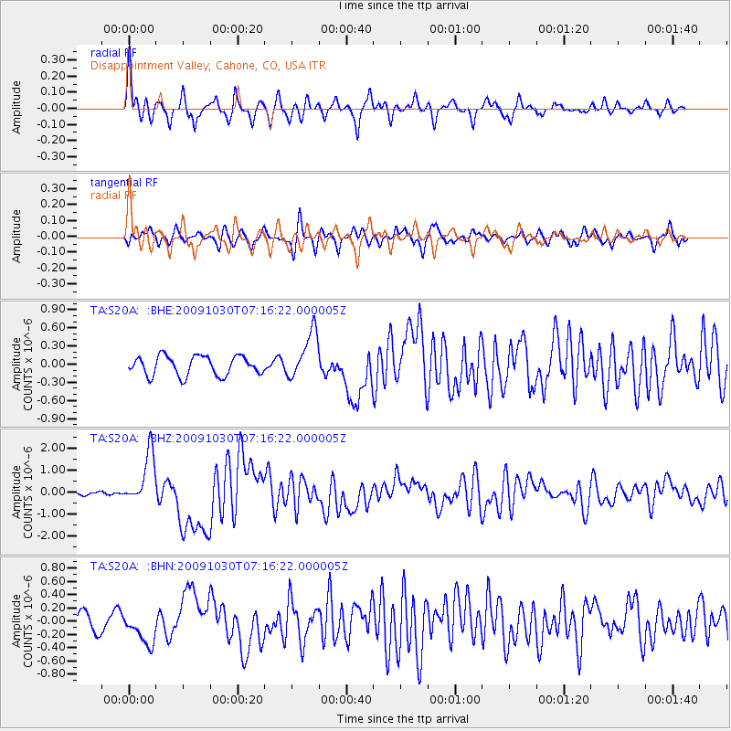
Signal To Noise
| Channel | StoN | STA | LTA |
| TA:S20A: :BHZ:20091030T07:16:22.000005Z | 7.6890106 | 1.2035542E-6 | 1.5652914E-7 |
| TA:S20A: :BHN:20091030T07:16:22.000005Z | 1.7232959 | 2.4127746E-7 | 1.4000932E-7 |
| TA:S20A: :BHE:20091030T07:16:22.000005Z | 2.5051248 | 3.9683727E-7 | 1.5841017E-7 |
| Arrivals |
| Ps | 3.2 SECOND |
| PpPs | 10 SECOND |
| PsPs/PpSs | 13 SECOND |


