You are here: Home > Network List > TA - USArray Transportable Network (new EarthScope stations) Stations List
> Station S20A Disappointment Valley, Cahone, CO, USA > Earthquake Result Viewer
S20A Disappointment Valley, Cahone, CO, USA - Earthquake Result Viewer

| Earthquake location: |
Kuril Islands |
| Earthquake latitude/longitude: |
50.8/155.0 |
| Earthquake time(UTC): |
2009/04/21 (111) 05:26:11 GMT |
| Earthquake Depth: |
152 km |
| Earthquake Magnitude: |
6.0 MB, 6.2 MW, 6.2 MW |
| Earthquake Catalog/Contributor: |
WHDF/NEIC |
|
| Network: |
TA USArray Transportable Network (new EarthScope stations) |
| Station: |
S20A Disappointment Valley, Cahone, CO, USA |
| Lat/Lon: |
37.83 N/108.36 W |
| Elevation: |
2355 m |
|
| Distance: |
65.5 deg |
| Az: |
59.788 deg |
| Baz: |
316.206 deg |
| Ray Param: |
0.05778077 |
| Estimated Moho Depth: |
49.0 km |
| Estimated Crust Vp/Vs: |
1.80 |
| Assumed Crust Vp: |
6.476 km/s |
| Estimated Crust Vs: |
3.608 km/s |
| Estimated Crust Poisson's Ratio: |
0.27 |
|
| Radial Match: |
90.286354 % |
| Radial Bump: |
400 |
| Transverse Match: |
74.30089 % |
| Transverse Bump: |
400 |
| SOD ConfigId: |
2658 |
| Insert Time: |
2010-03-06 20:35:58.828 +0000 |
| GWidth: |
2.5 |
| Max Bumps: |
400 |
| Tol: |
0.001 |
|
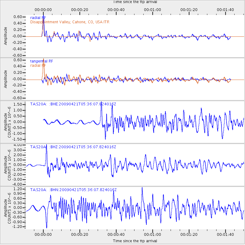
Signal To Noise
| Channel | StoN | STA | LTA |
| TA:S20A: :BHZ:20090421T05:36:07.824016Z | 9.690456 | 1.4256386E-6 | 1.4711779E-7 |
| TA:S20A: :BHN:20090421T05:36:07.824016Z | 2.8544855 | 4.7054542E-7 | 1.6484421E-7 |
| TA:S20A: :BHE:20090421T05:36:07.824016Z | 5.5944815 | 6.5345216E-7 | 1.1680299E-7 |
| Arrivals |
| Ps | 6.3 SECOND |
| PpPs | 20 SECOND |
| PsPs/PpSs | 27 SECOND |


