You are here: Home > Network List > CI - Caltech Regional Seismic Network Stations List
> Station MPM Manuel Prospect Mine, California, USA > Earthquake Result Viewer
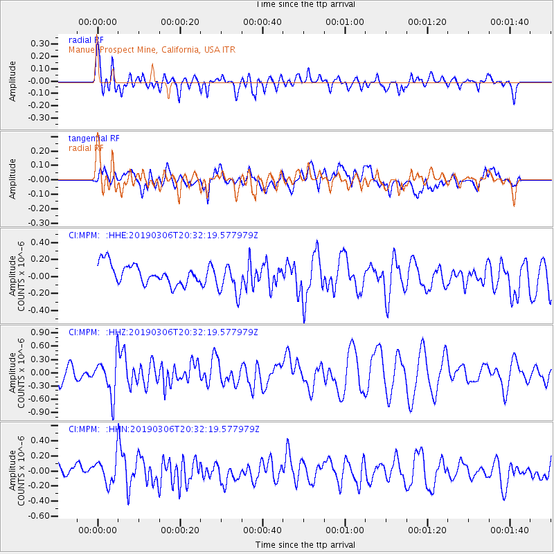
MPM Manuel Prospect Mine, California, USA - Earthquake Result Viewer
*The percent match for this event was below the threshold and hence no stack was calculated.
| Earthquake location: |
South Of Kermadec Islands |
| Earthquake latitude/longitude: |
-32.3/-177.8 |
| Earthquake time(UTC): |
2019/03/06 (065) 20:19:58 GMT |
| Earthquake Depth: |
7.1 km |
| Earthquake Magnitude: |
5.7 Mww |
| Earthquake Catalog/Contributor: |
NEIC PDE/us |
|
| Network: |
CI Caltech Regional Seismic Network |
| Station: |
MPM Manuel Prospect Mine, California, USA |
| Lat/Lon: |
36.06 N/117.49 W |
| Elevation: |
185 m |
|
| Distance: |
88.3 deg |
| Az: |
44.758 deg |
| Baz: |
227.412 deg |
| Ray Param: |
$rayparam |
*The percent match for this event was below the threshold and hence was not used in the summary stack. |
|
| Radial Match: |
72.53418 % |
| Radial Bump: |
400 |
| Transverse Match: |
49.908188 % |
| Transverse Bump: |
400 |
| SOD ConfigId: |
13570011 |
| Insert Time: |
2019-05-02 16:25:34.117 +0000 |
| GWidth: |
2.5 |
| Max Bumps: |
400 |
| Tol: |
0.001 |
|
Signal To Noise
| Channel | StoN | STA | LTA |
| CI:MPM: :HHZ:20190306T20:32:19.577979Z | 3.0242734 | 4.4891627E-7 | 1.4843773E-7 |
| CI:MPM: :HHN:20190306T20:32:19.577979Z | 1.4231951 | 1.9089185E-7 | 1.3412908E-7 |
| CI:MPM: :HHE:20190306T20:32:19.577979Z | 1.5979718 | 1.8598179E-7 | 1.1638615E-7 |
| Arrivals |
| Ps | |
| PpPs | |
| PsPs/PpSs | |


