You are here: Home > Network List > UW - Pacific Northwest Regional Seismic Network Stations List
> Station HOOD Mt Hood Meadows, OR CREST BB SMO > Earthquake Result Viewer
HOOD Mt Hood Meadows, OR CREST BB SMO - Earthquake Result Viewer
*The percent match for this event was below the threshold and hence no stack was calculated.
| Earthquake location: |
South Of Kermadec Islands |
| Earthquake latitude/longitude: |
-32.6/-177.1 |
| Earthquake time(UTC): |
2019/03/07 (066) 15:27:24 GMT |
| Earthquake Depth: |
10 km |
| Earthquake Magnitude: |
5.5 Mww |
| Earthquake Catalog/Contributor: |
NEIC PDE/us |
|
| Network: |
UW Pacific Northwest Regional Seismic Network |
| Station: |
HOOD Mt Hood Meadows, OR CREST BB SMO |
| Lat/Lon: |
45.32 N/121.65 W |
| Elevation: |
1520 m |
|
| Distance: |
92.4 deg |
| Az: |
35.537 deg |
| Baz: |
224.062 deg |
| Ray Param: |
$rayparam |
*The percent match for this event was below the threshold and hence was not used in the summary stack. |
|
| Radial Match: |
60.098824 % |
| Radial Bump: |
400 |
| Transverse Match: |
79.713326 % |
| Transverse Bump: |
400 |
| SOD ConfigId: |
13570011 |
| Insert Time: |
2019-05-02 16:35:26.532 +0000 |
| GWidth: |
2.5 |
| Max Bumps: |
400 |
| Tol: |
0.001 |
|
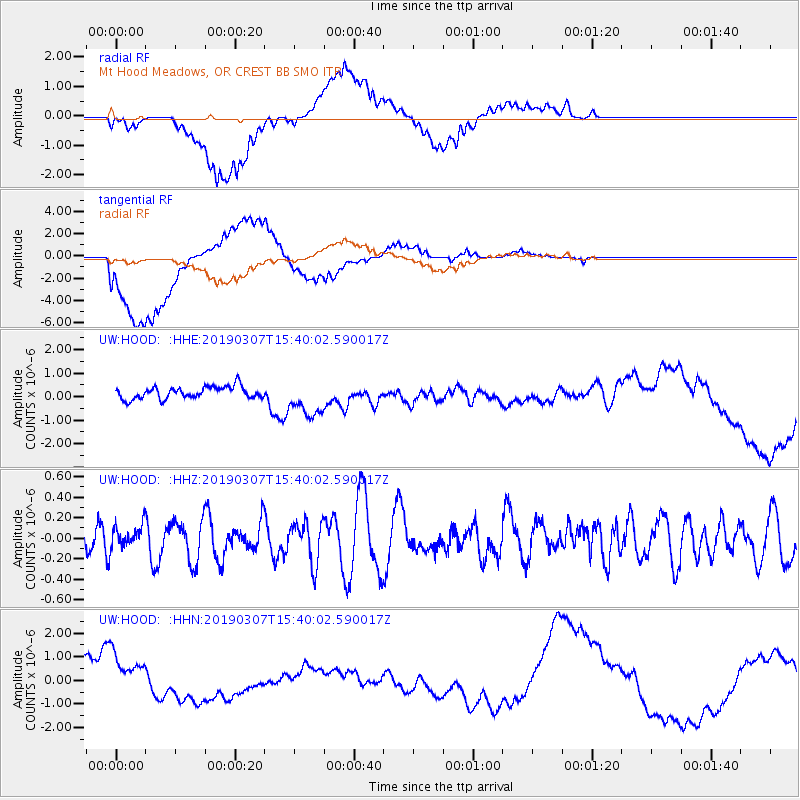
Signal To Noise
| Channel | StoN | STA | LTA |
| UW:HOOD: :HHZ:20190307T15:40:02.590017Z | 0.9483033 | 1.0806177E-7 | 1.1395275E-7 |
| UW:HOOD: :HHN:20190307T15:40:02.590017Z | 1.6454419 | 8.4303815E-7 | 5.123476E-7 |
| UW:HOOD: :HHE:20190307T15:40:02.590017Z | 3.0761845 | 7.866368E-7 | 2.5571833E-7 |
| Arrivals |
| Ps | |
| PpPs | |
| PsPs/PpSs | |


