You are here: Home > Network List > UU - University of Utah Regional Network Stations List
> Station TMU Trail Mountain (BB), UT, USA > Earthquake Result Viewer
TMU Trail Mountain (BB), UT, USA - Earthquake Result Viewer
| Earthquake location: |
Tonga Islands |
| Earthquake latitude/longitude: |
-18.1/-175.0 |
| Earthquake time(UTC): |
2016/09/24 (268) 21:07:13 GMT |
| Earthquake Depth: |
179 km |
| Earthquake Magnitude: |
6.3 MO |
| Earthquake Catalog/Contributor: |
NEIC PDE/NEIC ALERT |
|
| Network: |
UU University of Utah Regional Network |
| Station: |
TMU Trail Mountain (BB), UT, USA |
| Lat/Lon: |
39.30 N/111.21 W |
| Elevation: |
2731 m |
|
| Distance: |
82.5 deg |
| Az: |
44.61 deg |
| Baz: |
239.412 deg |
| Ray Param: |
0.046445142 |
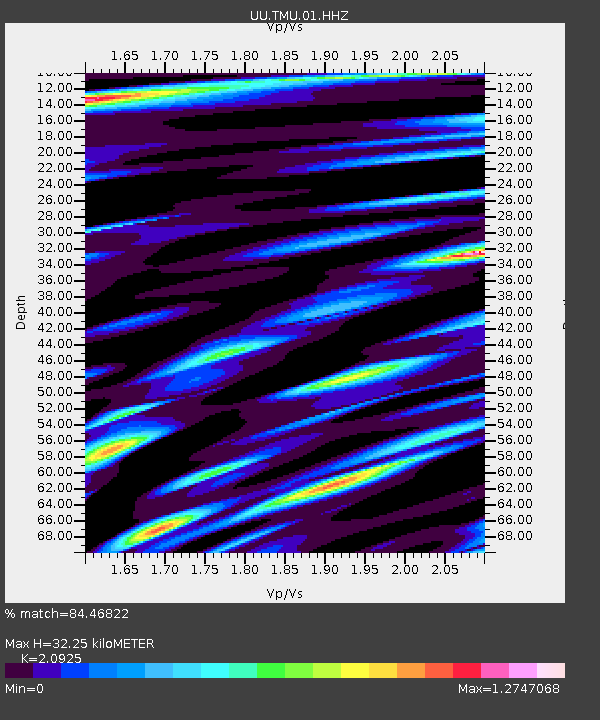
| Estimated Moho Depth: |
32.25 km |
| Estimated Crust Vp/Vs: |
2.09 |
| Assumed Crust Vp: |
6.207 km/s |
| Estimated Crust Vs: |
2.966 km/s |
| Estimated Crust Poisson's Ratio: |
0.35 |
|
| Radial Match: |
84.46822 % |
| Radial Bump: |
400 |
| Transverse Match: |
68.26453 % |
| Transverse Bump: |
400 |
| SOD ConfigId: |
1634031 |
| Insert Time: |
2016-10-08 21:11:32.897 +0000 |
| GWidth: |
2.5 |
| Max Bumps: |
400 |
| Tol: |
0.001 |
|

Signal To Noise
| Channel | StoN | STA | LTA |
| UU:TMU:01:HHZ:20160924T21:18:44.179993Z | 3.4394698 | 9.116082E-9 | 2.6504323E-9 |
| UU:TMU:01:HHN:20160924T21:18:44.179993Z | 0.94701743 | 3.1183636E-9 | 3.292826E-9 |
| UU:TMU:01:HHE:20160924T21:18:44.179993Z | 1.9579158 | 8.776337E-9 | 4.4824895E-9 |
| Arrivals |
| Ps | 5.8 SECOND |
| PpPs | 16 SECOND |
| PsPs/PpSs | 22 SECOND |


