You are here: Home > Network List > IU - Global Seismograph Network (GSN - IRIS/USGS) Stations List
> Station PMG Port Moresby, New Guinea > Earthquake Result Viewer
PMG Port Moresby, New Guinea - Earthquake Result Viewer
| Earthquake location: |
Tonga Islands |
| Earthquake latitude/longitude: |
-20.7/-174.0 |
| Earthquake time(UTC): |
2009/11/24 (328) 12:47:15 GMT |
| Earthquake Depth: |
18 km |
| Earthquake Magnitude: |
6.4 MB, 6.8 MS, 6.8 MW, 6.7 MW |
| Earthquake Catalog/Contributor: |
WHDF/NEIC |
|
| Network: |
IU Global Seismograph Network (GSN - IRIS/USGS) |
| Station: |
PMG Port Moresby, New Guinea |
| Lat/Lon: |
9.40 S/147.16 E |
| Elevation: |
90 m |
|
| Distance: |
39.0 deg |
| Az: |
280.833 deg |
| Baz: |
111.274 deg |
| Ray Param: |
0.075205855 |
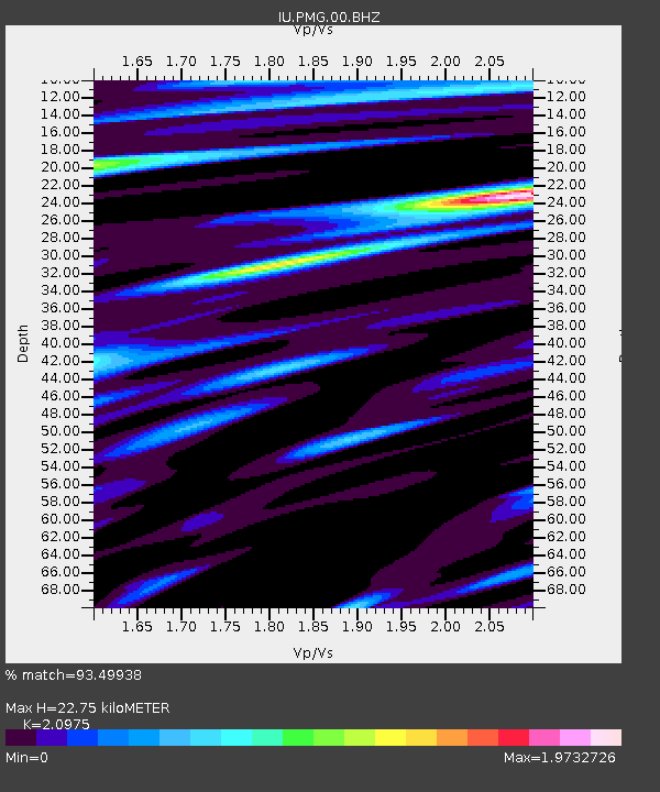
| Estimated Moho Depth: |
22.75 km |
| Estimated Crust Vp/Vs: |
2.10 |
| Assumed Crust Vp: |
6.122 km/s |
| Estimated Crust Vs: |
2.919 km/s |
| Estimated Crust Poisson's Ratio: |
0.35 |
|
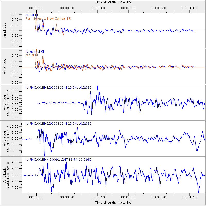
| Radial Match: |
93.49938 % |
| Radial Bump: |
400 |
| Transverse Match: |
74.39259 % |
| Transverse Bump: |
400 |
| SOD ConfigId: |
1 |
| Insert Time: |
2010-02-19 01:15:45.705 +0000 |
| GWidth: |
2.5 |
| Max Bumps: |
400 |
| Tol: |
0.001 |
|
Signal To Noise
| Channel | StoN | STA | LTA |
| IU:PMG:00:BHZ:20091124T12:54:10.298Z | 41.394596 | 4.7793724E-6 | 1.15458846E-7 |
| IU:PMG:00:BHN:20091124T12:54:10.298Z | 11.190395 | 1.1418974E-6 | 1.0204263E-7 |
| IU:PMG:00:BHE:20091124T12:54:10.298Z | 19.316122 | 2.4677347E-6 | 1.2775519E-7 |
| Arrivals |
| Ps | 4.3 SECOND |
| PpPs | 11 SECOND |
| PsPs/PpSs | 15 SECOND |


