You are here: Home > Network List > TA - USArray Transportable Network (new EarthScope stations) Stations List
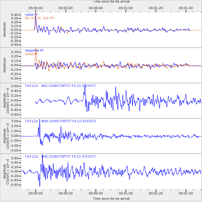
> Station F12A Elk City, ID, USA > Earthquake Result Viewer
F12A Elk City, ID, USA - Earthquake Result Viewer
| Earthquake location: |
Ryukyu Islands, Japan |
| Earthquake latitude/longitude: |
27.5/128.3 |
| Earthquake time(UTC): |
2008/07/08 (190) 07:42:10 GMT |
| Earthquake Depth: |
43 km |
| Earthquake Magnitude: |
6.0 MB, 5.5 MS, 6.0 MW, 6.0 MW |
| Earthquake Catalog/Contributor: |
WHDF/NEIC |
|
| Network: |
TA USArray Transportable Network (new EarthScope stations) |
| Station: |
F12A Elk City, ID, USA |
| Lat/Lon: |
45.76 N/115.25 W |
| Elevation: |
1442 m |
|
| Distance: |
87.0 deg |
| Az: |
38.894 deg |
| Baz: |
307.212 deg |
| Ray Param: |
0.04355087 |
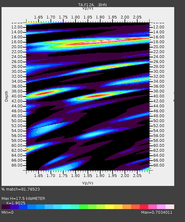
| Estimated Moho Depth: |
17.5 km |
| Estimated Crust Vp/Vs: |
1.90 |
| Assumed Crust Vp: |
6.577 km/s |
| Estimated Crust Vs: |
3.457 km/s |
| Estimated Crust Poisson's Ratio: |
0.31 |
|
| Radial Match: |
81.76523 % |
| Radial Bump: |
400 |
| Transverse Match: |
70.20281 % |
| Transverse Bump: |
400 |
| SOD ConfigId: |
2504 |
| Insert Time: |
2010-03-06 20:37:32.115 +0000 |
| GWidth: |
2.5 |
| Max Bumps: |
400 |
| Tol: |
0.001 |
|
Signal To Noise
| Channel | StoN | STA | LTA |
| TA:F12A: :BHN:20080708T07:54:20.425007Z | 19.01621 | 1.1544365E-6 | 6.0708025E-8 |
| TA:F12A: :BHE:20080708T07:54:20.425007Z | 5.543334 | 2.7771588E-7 | 5.009907E-8 |
| TA:F12A: :BHZ:20080708T07:54:20.425007Z | 4.153964 | 2.6732067E-7 | 6.435315E-8 |
| Arrivals |
| Ps | 2.5 SECOND |
| PpPs | 7.6 SECOND |
| PsPs/PpSs | 10 SECOND |


