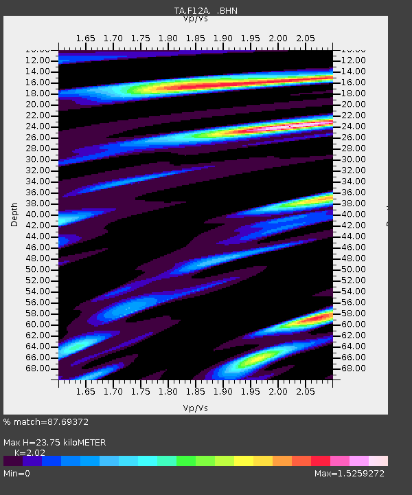
F12A Elk City, ID, USA - Earthquake Result Viewer
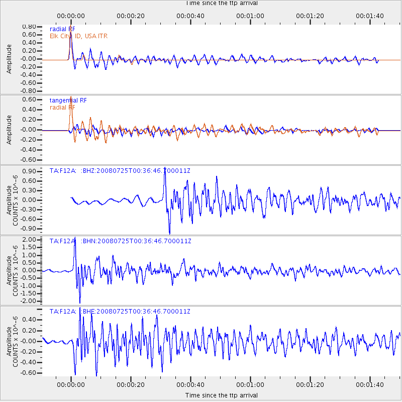
Earthquake location: Rat Islands, Aleutian Islands
Earthquake latitude/longitude: 51.3/179.0
Earthquake time(UTC): 2008/07/25 (207) 00:29:22 GMT
Earthquake Depth: 21 km
Earthquake Magnitude: 5.7 MB, 5.5 MS, 5.9 MW, 5.9 MW
Earthquake Catalog/Contributor: WHDF/NEIC
Network: TA USArray Transportable Network (new EarthScope stations)
Station: F12A Elk City, ID, USA
Lat/Lon: 45.76 N/115.25 W
Elevation: 1442 m
Distance: 42.6 deg
Az: 70.599 deg
Baz: 302.202 deg
Ray Param: 0.07305544
Estimated Moho Depth: 23.75 km
Estimated Crust Vp/Vs: 2.02
Assumed Crust Vp: 6.577 km/s
Estimated Crust Vs: 3.256 km/s
Estimated Crust Poisson's Ratio: 0.34
Radial Match: 87.69372 %
Radial Bump: 400
Transverse Match: 74.334816 %
Transverse Bump: 400
SOD ConfigId: 2504
Insert Time: 2010-03-06 20:37:42.534 +0000
GWidth: 2.5
Max Bumps: 400
Tol: 0.001

Signal To Noise

ChannelStoNSTALTA
TA:F12A: :BHN:20080725T00:36:46.700011Z18.6115688.738415E-74.6951524E-8
TA:F12A: :BHE:20080725T00:36:46.700011Z5.1715782.7812285E-75.3779107E-8
TA:F12A: :BHZ:20080725T00:36:46.700011Z6.003054.35195E-77.249565E-8
Arrivals
Ps3.9 SECOND
PpPs10 SECOND
PsPs/PpSs14 SECOND