You are here: Home > Network List > TA - USArray Transportable Network (new EarthScope stations) Stations List
> Station F12A Elk City, ID, USA > Earthquake Result Viewer
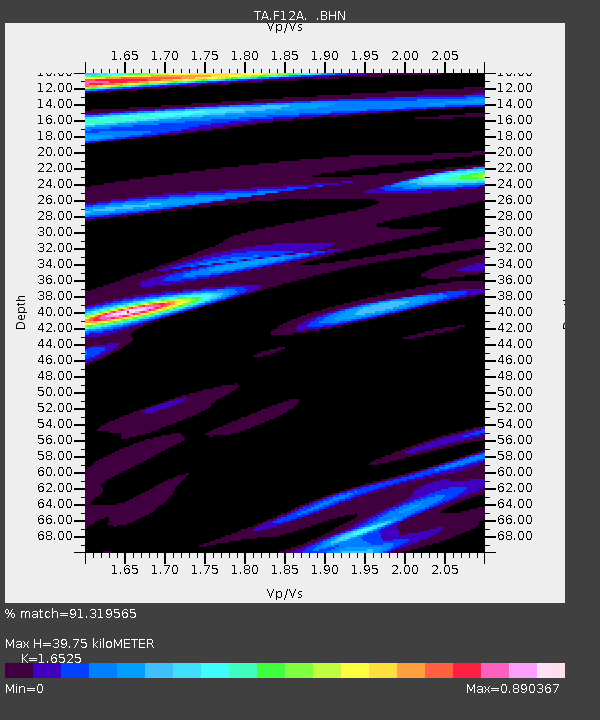
F12A Elk City, ID, USA - Earthquake Result Viewer
| Earthquake location: |
Peru-Brazil Border Region |
| Earthquake latitude/longitude: |
-7.6/-74.4 |
| Earthquake time(UTC): |
2008/08/26 (239) 21:00:36 GMT |
| Earthquake Depth: |
154 km |
| Earthquake Magnitude: |
6.0 MB, 6.4 MW, 6.4 MW |
| Earthquake Catalog/Contributor: |
WHDF/NEIC |
|
| Network: |
TA USArray Transportable Network (new EarthScope stations) |
| Station: |
F12A Elk City, ID, USA |
| Lat/Lon: |
45.76 N/115.25 W |
| Elevation: |
1442 m |
|
| Distance: |
64.5 deg |
| Az: |
329.495 deg |
| Baz: |
134.054 deg |
| Ray Param: |
0.05843689 |
| Estimated Moho Depth: |
39.75 km |
| Estimated Crust Vp/Vs: |
1.65 |
| Assumed Crust Vp: |
6.577 km/s |
| Estimated Crust Vs: |
3.98 km/s |
| Estimated Crust Poisson's Ratio: |
0.21 |
|
| Radial Match: |
91.319565 % |
| Radial Bump: |
400 |
| Transverse Match: |
81.31533 % |
| Transverse Bump: |
400 |
| SOD ConfigId: |
2504 |
| Insert Time: |
2010-03-06 20:37:47.650 +0000 |
| GWidth: |
2.5 |
| Max Bumps: |
400 |
| Tol: |
0.001 |
|

Signal To Noise
| Channel | StoN | STA | LTA |
| TA:F12A: :BHN:20080826T21:10:26.125015Z | 33.477554 | 2.3857872E-6 | 7.1265276E-8 |
| TA:F12A: :BHE:20080826T21:10:26.125015Z | 8.266415 | 5.9932466E-7 | 7.250116E-8 |
| TA:F12A: :BHZ:20080826T21:10:26.125015Z | 4.98968 | 5.991574E-7 | 1.2007932E-7 |
| Arrivals |
| Ps | 4.1 SECOND |
| PpPs | 15 SECOND |
| PsPs/PpSs | 19 SECOND |


