You are here: Home > Network List > IU - Global Seismograph Network (GSN - IRIS/USGS) Stations List
> Station PMG Port Moresby, New Guinea > Earthquake Result Viewer
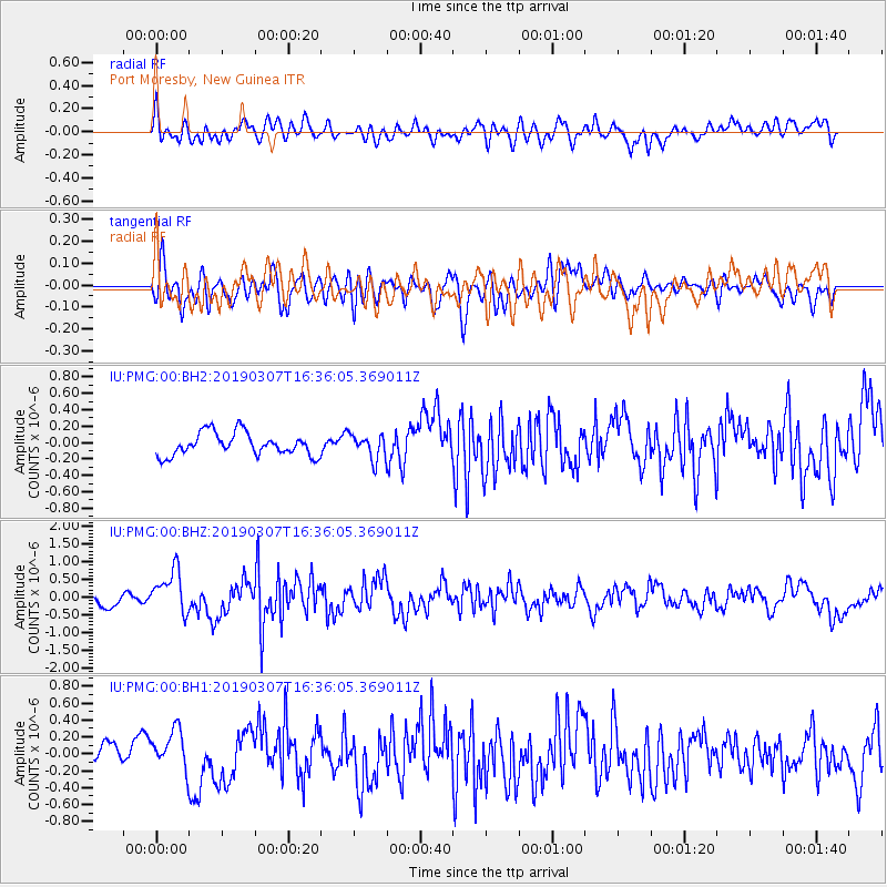
PMG Port Moresby, New Guinea - Earthquake Result Viewer
*The percent match for this event was below the threshold and hence no stack was calculated.
| Earthquake location: |
South Of Kermadec Islands |
| Earthquake latitude/longitude: |
-32.5/-178.4 |
| Earthquake time(UTC): |
2019/03/07 (066) 16:29:09 GMT |
| Earthquake Depth: |
21 km |
| Earthquake Magnitude: |
5.7 Mww |
| Earthquake Catalog/Contributor: |
NEIC PDE/us |
|
| Network: |
IU Global Seismograph Network (GSN - IRIS/USGS) |
| Station: |
PMG Port Moresby, New Guinea |
| Lat/Lon: |
9.40 S/147.16 E |
| Elevation: |
90 m |
|
| Distance: |
39.2 deg |
| Az: |
298.077 deg |
| Baz: |
130.904 deg |
| Ray Param: |
$rayparam |
*The percent match for this event was below the threshold and hence was not used in the summary stack. |
|
| Radial Match: |
73.387314 % |
| Radial Bump: |
400 |
| Transverse Match: |
64.90763 % |
| Transverse Bump: |
400 |
| SOD ConfigId: |
13570011 |
| Insert Time: |
2019-05-02 16:47:55.772 +0000 |
| GWidth: |
2.5 |
| Max Bumps: |
400 |
| Tol: |
0.001 |
|
Signal To Noise
| Channel | StoN | STA | LTA |
| IU:PMG:00:BHZ:20190307T16:36:05.369011Z | 2.3840833 | 6.095647E-7 | 2.5568096E-7 |
| IU:PMG:00:BH1:20190307T16:36:05.369011Z | 1.1750846 | 2.2646256E-7 | 1.9272022E-7 |
| IU:PMG:00:BH2:20190307T16:36:05.369011Z | 1.0856434 | 1.4887434E-7 | 1.3713004E-7 |
| Arrivals |
| Ps | |
| PpPs | |
| PsPs/PpSs | |


