You are here: Home > Network List > TA - USArray Transportable Network (new EarthScope stations) Stations List
> Station F12A Elk City, ID, USA > Earthquake Result Viewer
F12A Elk City, ID, USA - Earthquake Result Viewer
| Earthquake location: |
South Of Fiji Islands |
| Earthquake latitude/longitude: |
-26.0/-177.5 |
| Earthquake time(UTC): |
2007/12/09 (343) 07:28:20 GMT |
| Earthquake Depth: |
152 km |
| Earthquake Magnitude: |
7.0 MB, 7.8 MW, 7.7 MW |
| Earthquake Catalog/Contributor: |
WHDF/NEIC |
|
| Network: |
TA USArray Transportable Network (new EarthScope stations) |
| Station: |
F12A Elk City, ID, USA |
| Lat/Lon: |
45.76 N/115.25 W |
| Elevation: |
1442 m |
|
| Distance: |
91.0 deg |
| Az: |
38.297 deg |
| Baz: |
232.813 deg |
| Ray Param: |
0.0415991 |
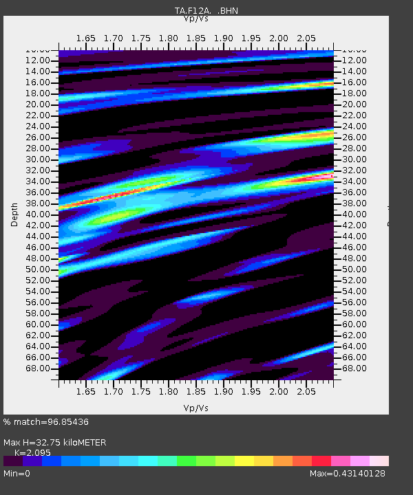
| Estimated Moho Depth: |
32.75 km |
| Estimated Crust Vp/Vs: |
2.10 |
| Assumed Crust Vp: |
6.577 km/s |
| Estimated Crust Vs: |
3.139 km/s |
| Estimated Crust Poisson's Ratio: |
0.35 |
|
| Radial Match: |
96.85436 % |
| Radial Bump: |
360 |
| Transverse Match: |
92.02567 % |
| Transverse Bump: |
400 |
| SOD ConfigId: |
2564 |
| Insert Time: |
2010-03-06 20:38:07.218 +0000 |
| GWidth: |
2.5 |
| Max Bumps: |
400 |
| Tol: |
0.001 |
|

Signal To Noise
| Channel | StoN | STA | LTA |
| TA:F12A: :BHN:20071209T07:40:36.525017Z | 1.7133664 | 2.5516337E-7 | 1.4892517E-7 |
| TA:F12A: :BHE:20071209T07:40:36.525017Z | 1.2766817 | 3.2239043E-7 | 2.5252217E-7 |
| TA:F12A: :BHZ:20071209T07:40:36.525017Z | 5.450427 | 9.753988E-7 | 1.7895825E-7 |
| Arrivals |
| Ps | 5.6 SECOND |
| PpPs | 15 SECOND |
| PsPs/PpSs | 21 SECOND |


