You are here: Home > Network List > AV - Alaska Volcano Observatory Stations List
> Station SPCR Ckakachatna River, Mount Spurr, Alaska > Earthquake Result Viewer
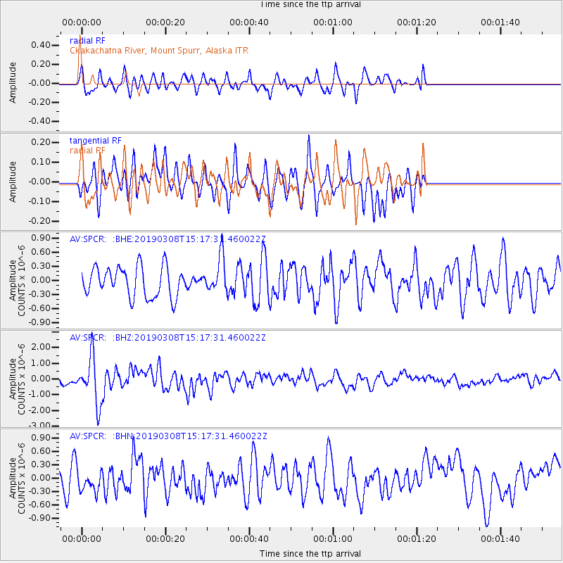
SPCR Ckakachatna River, Mount Spurr, Alaska - Earthquake Result Viewer
*The percent match for this event was below the threshold and hence no stack was calculated.
| Earthquake location: |
Philippine Islands Region |
| Earthquake latitude/longitude: |
10.4/126.1 |
| Earthquake time(UTC): |
2019/03/08 (067) 15:06:16 GMT |
| Earthquake Depth: |
54 km |
| Earthquake Magnitude: |
6.0 Mww |
| Earthquake Catalog/Contributor: |
NEIC PDE/us |
|
| Network: |
AV Alaska Volcano Observatory |
| Station: |
SPCR Ckakachatna River, Mount Spurr, Alaska |
| Lat/Lon: |
61.20 N/152.21 W |
| Elevation: |
984 m |
|
| Distance: |
77.0 deg |
| Az: |
29.461 deg |
| Baz: |
267.803 deg |
| Ray Param: |
$rayparam |
*The percent match for this event was below the threshold and hence was not used in the summary stack. |
|
| Radial Match: |
67.801254 % |
| Radial Bump: |
385 |
| Transverse Match: |
59.425182 % |
| Transverse Bump: |
358 |
| SOD ConfigId: |
13570011 |
| Insert Time: |
2019-05-02 16:51:53.215 +0000 |
| GWidth: |
2.5 |
| Max Bumps: |
400 |
| Tol: |
0.001 |
|
Signal To Noise
| Channel | StoN | STA | LTA |
| AV:SPCR: :BHZ:20190308T15:17:31.460022Z | 3.7159622 | 1.5210034E-6 | 4.093162E-7 |
| AV:SPCR: :BHN:20190308T15:17:31.460022Z | 0.6307322 | 2.3225464E-7 | 3.6823022E-7 |
| AV:SPCR: :BHE:20190308T15:17:31.460022Z | 1.2389069 | 3.9196215E-7 | 3.1637742E-7 |
| Arrivals |
| Ps | |
| PpPs | |
| PsPs/PpSs | |


