You are here: Home > Network List > TA - USArray Transportable Network (new EarthScope stations) Stations List
> Station F12A Elk City, ID, USA > Earthquake Result Viewer
F12A Elk City, ID, USA - Earthquake Result Viewer
| Earthquake location: |
Northwest Of Ryukyu Islands |
| Earthquake latitude/longitude: |
27.3/126.9 |
| Earthquake time(UTC): |
2007/07/31 (212) 15:07:35 GMT |
| Earthquake Depth: |
10 km |
| Earthquake Magnitude: |
5.5 MB, 5.7 MS, 5.9 MW, 5.9 MW |
| Earthquake Catalog/Contributor: |
WHDF/NEIC |
|
| Network: |
TA USArray Transportable Network (new EarthScope stations) |
| Station: |
F12A Elk City, ID, USA |
| Lat/Lon: |
45.76 N/115.25 W |
| Elevation: |
1442 m |
|
| Distance: |
88.0 deg |
| Az: |
38.273 deg |
| Baz: |
308.094 deg |
| Ray Param: |
0.04293001 |
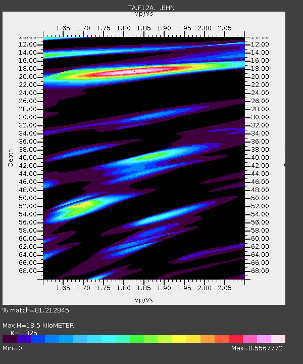
| Estimated Moho Depth: |
18.5 km |
| Estimated Crust Vp/Vs: |
1.83 |
| Assumed Crust Vp: |
6.577 km/s |
| Estimated Crust Vs: |
3.604 km/s |
| Estimated Crust Poisson's Ratio: |
0.29 |
|
| Radial Match: |
81.212845 % |
| Radial Bump: |
400 |
| Transverse Match: |
60.95942 % |
| Transverse Bump: |
400 |
| SOD ConfigId: |
2564 |
| Insert Time: |
2010-03-06 20:38:30.038 +0000 |
| GWidth: |
2.5 |
| Max Bumps: |
400 |
| Tol: |
0.001 |
|

Signal To Noise
| Channel | StoN | STA | LTA |
| TA:F12A: :BHN:20070731T15:19:53.850029Z | 2.5757408 | 7.377219E-8 | 2.8641157E-8 |
| TA:F12A: :BHE:20070731T15:19:53.850029Z | 0.38964087 | 2.1723176E-8 | 5.575179E-8 |
| TA:F12A: :BHZ:20070731T15:19:53.850029Z | 2.8188396 | 1.4942351E-7 | 5.3008872E-8 |
| Arrivals |
| Ps | 2.4 SECOND |
| PpPs | 7.8 SECOND |
| PsPs/PpSs | 10 SECOND |


