You are here: Home > Network List > TA - USArray Transportable Network (new EarthScope stations) Stations List
> Station F12A Elk City, ID, USA > Earthquake Result Viewer
F12A Elk City, ID, USA - Earthquake Result Viewer
| Earthquake location: |
Komandorskiye Ostrova Region |
| Earthquake latitude/longitude: |
53.6/169.7 |
| Earthquake time(UTC): |
2007/07/29 (210) 04:54:36 GMT |
| Earthquake Depth: |
26 km |
| Earthquake Magnitude: |
6.0 MB, 5.5 MS, 5.9 MW, 5.8 MW |
| Earthquake Catalog/Contributor: |
WHDF/NEIC |
|
| Network: |
TA USArray Transportable Network (new EarthScope stations) |
| Station: |
F12A Elk City, ID, USA |
| Lat/Lon: |
45.76 N/115.25 W |
| Elevation: |
1442 m |
|
| Distance: |
47.1 deg |
| Az: |
67.513 deg |
| Baz: |
308.204 deg |
| Ray Param: |
0.070198104 |
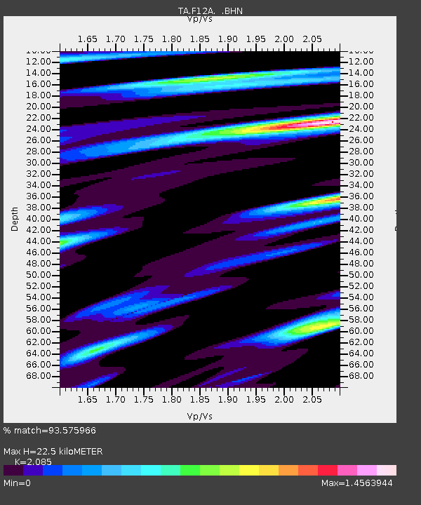
| Estimated Moho Depth: |
22.5 km |
| Estimated Crust Vp/Vs: |
2.09 |
| Assumed Crust Vp: |
6.577 km/s |
| Estimated Crust Vs: |
3.154 km/s |
| Estimated Crust Poisson's Ratio: |
0.35 |
|
| Radial Match: |
93.575966 % |
| Radial Bump: |
375 |
| Transverse Match: |
82.89321 % |
| Transverse Bump: |
400 |
| SOD ConfigId: |
2564 |
| Insert Time: |
2010-03-06 20:38:31.827 +0000 |
| GWidth: |
2.5 |
| Max Bumps: |
400 |
| Tol: |
0.001 |
|

Signal To Noise
| Channel | StoN | STA | LTA |
| TA:F12A: :BHN:20070729T05:02:35.350015Z | 3.7893307 | 1.0195376E-7 | 2.6905479E-8 |
| TA:F12A: :BHE:20070729T05:02:35.350015Z | 3.6758473 | 1.2644068E-7 | 3.43977E-8 |
| TA:F12A: :BHZ:20070729T05:02:35.350015Z | 6.706379 | 3.3859504E-7 | 5.0488506E-8 |
| Arrivals |
| Ps | 3.9 SECOND |
| PpPs | 10.0 SECOND |
| PsPs/PpSs | 14 SECOND |


